


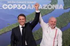


New UCLA research reveals worrying land degradation in northeast Brazil – Latin America Reports
Report on Land Degradation in Northeastern Brazil and its Impact on Sustainable Development Goals
Executive Summary
A comprehensive analysis of land use and land cover (LULC) data from 2000 to 2020 in northeastern Brazil reveals extensive land transformation and degradation, posing significant challenges to the achievement of the United Nations Sustainable Development Goals (SDGs). Research from the University of California, Los Angeles (UCLA) highlights widespread deforestation and agricultural expansion, directly impacting SDG 15 (Life on Land), SDG 2 (Zero Hunger), and SDG 13 (Climate Action). The development of a new, more detailed LULC dataset provides a critical tool for monitoring these environmental changes and formulating policies aligned with the 2030 Agenda for Sustainable Development.
Key Findings: Direct Threats to SDG 15 (Life on Land)
The study documents severe degradation across multiple Brazilian biomes, undermining progress towards SDG 15, which aims to protect, restore, and promote sustainable use of terrestrial ecosystems, halt deforestation, and reverse land degradation.
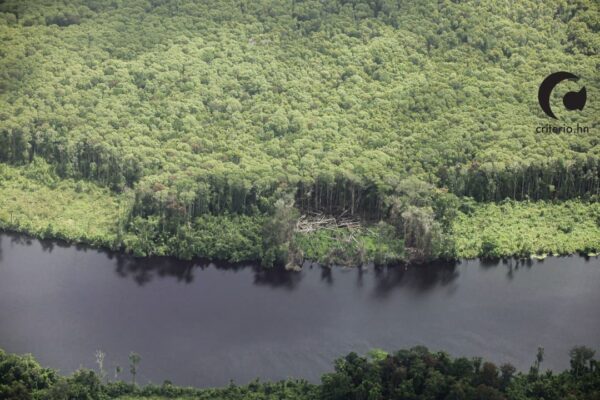
- The Caatinga Biome: This semi-arid region has suffered immense losses, directly contravening SDG Target 15.3 (combat desertification, restore degraded land and soil).
- A total of 100,000 square kilometers of native forest and grassland were lost between 2000 and 2020.
- The biome’s degradation has been historically underrepresented due to misclassification, obscuring the true scale of the environmental challenge.
- The Intergovernmental Panel on Climate Change (IPCC) has classified the Caatinga as a hotspot of climate risk, linking its degradation directly to SDG 13 (Climate Action).
- The Cerrado Savanna: This biome is identified as a “deforestation hotspot,” representing a failure to meet SDG Target 15.2 (end deforestation).
- Unsustainable agricultural expansion is the primary driver of this habitat loss.
- The Amazon and Atlantic Forests: These critical ecosystems face ongoing threats that jeopardize biodiversity and conservation gains, impacting SDG Target 15.5 (protect biodiversity and natural habitats).
- Significant deforestation has been observed near protected areas in the Amazon.
- The Atlantic Forest, a region of high endemism, has already been degraded by 88% of its original extent.
- Conservation data may be overestimated due to the misclassification of non-native eucalyptus plantations as natural forest.
Agricultural Expansion and its Conflict with SDGs 2 and 15
The report quantifies the expansion of agriculture and its role as a primary driver of environmental degradation, highlighting the urgent need to balance food security with ecosystem preservation.
- Scale of Expansion: Farming activities grew by 34,000 square kilometers in the region during the study period.
- Environmental Impact: This expansion is a leading cause of deforestation and land degradation in the Cerrado and Caatinga biomes.
- SDG Conflict: This trend demonstrates a critical conflict between achieving SDG 2 (Zero Hunger) and SDG 15 (Life on Land). It underscores the necessity of advancing SDG Target 2.4, which calls for ensuring sustainable food production systems and implementing resilient agricultural practices that help maintain ecosystems.
Advanced Monitoring and Policy Implications for SDGs 13 and 17
The research introduces a new LULC dataset that serves as a vital instrument for evidence-based policymaking, crucial for advancing multiple SDGs.
- Improved Data for Policy: The new UCLA dataset provides more specific classifications than the national reference map, particularly by identifying shrublands. This enhanced accuracy allows for a more precise analysis of land coverage changes, which is fundamental for effective environmental planning and monitoring.
- Supporting Climate Action (SDG 13): By providing a clearer picture of deforestation and land degradation, the data helps quantify impacts on carbon sinks and climate resilience, supporting national efforts to meet climate targets under SDG 13.
- Fostering Partnerships (SDG 17): The report emphasizes the need for greater collaboration to address these challenges, in line with SDG 17 (Partnerships for the Goals). Key recommendations include:
- Increased investment in local universities and regional research centers to lead studies on degradation.
- The use of high-resolution satellite data to improve the accuracy of LULC classifications.
- The development of targeted local policies, particularly for the northern region of Brazil, which is identified as the least protected area in the nation.
Future Research: Linking Environmental and Social Dimensions
Future research aims to connect the environmental data with socio-economic indicators, creating a holistic understanding of the impacts of land degradation on human well-being. This approach will explore the correlation between land use changes and social variables such as mortality and unemployment, linking the findings to SDG 1 (No Poverty) and SDG 8 (Decent Work and Economic Growth).
Analysis of SDGs, Targets, and Indicators
-
SDG 15: Life on Land
- The article’s central theme is the degradation of terrestrial ecosystems in northeastern Brazil. It explicitly discusses the loss of forest and grassland in the Caatinga biome, widespread deforestation in the Cerrado, and the severe degradation of the Atlantic forest. This directly addresses the goal of protecting, restoring, and promoting the sustainable use of terrestrial ecosystems.
-
SDG 2: Zero Hunger
- The article connects land degradation directly to agricultural practices. It states that “farming grew by 34,000 square kilometers” and that “Agricultural expansion has caused significant damage in the Cerrado.” This highlights the challenge of achieving food security (a component of SDG 2) without causing environmental harm, pointing to the need for sustainable food production systems.
-
SDG 13: Climate Action
- The article links land degradation to climate change by citing an IPCC report that classified the Caatinga as a “hotspot of climate risk.” This underscores the connection between ecosystem health and climate resilience, making climate action a relevant goal.
-
SDG 17: Partnerships for the Goals
- A significant portion of the article focuses on the development of a new dataset and LULC map by UCLA researchers. It emphasizes the need for better data to inform policy and calls for “more investment from local universities in studying this degradation.” This relates to strengthening the means of implementation, particularly through science, technology, and capacity-building for data monitoring.
Identified SDG Targets
-
SDG 15: Life on Land
- Target 15.1: Ensure the conservation, restoration and sustainable use of terrestrial and inland freshwater ecosystems. The article highlights the failure to meet this target by reporting that the Caatinga “lost 100,000 square kilometers of both forest and grassland.”
- Target 15.2: Promote the implementation of sustainable management of all types of forests, halt deforestation, restore degraded forests. The article identifies the Cerrado as a “deforestation hotspot” and notes “widespread deforestation was also observed near protected areas in the Amazon rainforest,” indicating that this target is not being met in the region.
- Target 15.3: Combat desertification, restore degraded land and soil. The focus on “high indices of land transformation and degradation” in the semi-arid Caatinga biome directly relates to the fight against desertification.
- Target 15.9: Integrate ecosystem and biodiversity values into national and local planning. The article supports this target by explaining that new LULC maps “can provide a more thorough understanding of land utilization, aiding in planning and monitoring environmental programs” and by calling for “more local policies.”
-
SDG 2: Zero Hunger
- Target 2.4: Ensure sustainable food production systems and implement resilient agricultural practices. The article implies a failure to meet this target by showing that agricultural expansion is a primary driver of deforestation and has “caused significant damage,” which is the opposite of a sustainable system that helps maintain ecosystems.
-
SDG 13: Climate Action
- Target 13.2: Integrate climate change measures into national policies, strategies and planning. The identification of the Caatinga as a “hotspot of climate risk” reinforces the urgent need to integrate climate adaptation and mitigation measures into land use planning for the region.
-
SDG 17: Partnerships for the Goals
- Target 17.18: Enhance capacity-building support… to increase significantly the availability of high-quality, timely and reliable data. The entire research project described, which created the “first land use and land cover dataset specifically designed around northeastern Brazil” with “more specific classifications,” is a direct contribution to this target.
Implied and Mentioned Indicators
-
Quantitative Indicators
- Area of land cover change: The article provides specific figures that can be used as indicators of land degradation, such as the loss of “100,000 square kilometers of both forest and grassland” and the growth of “farming… by 34,000 square kilometers” between 2000 and 2020.
- Proportion of biome degradation: The statement that the Atlantic forest “has already been degraded by 88% from its original extent” serves as a stark indicator of habitat loss.
-
Qualitative and Process-based Indicators
- Availability of disaggregated data: The creation of the new LULC map by UCLA is itself an indicator of progress in data availability for environmental monitoring. The article notes its classifications are more specific than the national reference, indicating an improvement in data quality.
- Identification of climate risk: The classification of the Caatinga as a “hotspot of climate risk” in the IPCC report is a qualitative indicator used to highlight the region’s vulnerability and the urgency for action.
- Accuracy of land cover classification: The article implies that an indicator of progress would be a reduction in the misclassification of Caatinga vegetation, which is “often misclassified as Cerrado or grasslands.” The new dataset aims to improve this.
Summary Table
| SDGs | Targets | Indicators |
|---|---|---|
| SDG 15: Life on Land |
15.2: Halt deforestation. 15.3: Combat desertification, restore degraded land. |
– Loss of 100,000 sq km of forest and grassland (2000-2020). – 88% degradation of the Atlantic forest from its original extent. – Identification of the Cerrado as a “deforestation hotspot.” |
| SDG 2: Zero Hunger | 2.4: Ensure sustainable food production systems. | – Growth of 34,000 sq km in farming area, causing “significant damage.” |
| SDG 13: Climate Action | 13.2: Integrate climate change measures into national policies. | – Classification of the Caatinga as a “hotspot of climate risk” by the IPCC. |
| SDG 17: Partnerships for the Goals | 17.18: Increase availability of high-quality, timely and reliable data. | – Creation of the first LULC dataset specifically for northeastern Brazil with more accurate classifications (e.g., for shrublands). |
Source: latinamericareports.com

What is Your Reaction?
 Like
0
Like
0
 Dislike
0
Dislike
0
 Love
0
Love
0
 Funny
0
Funny
0
 Angry
0
Angry
0
 Sad
0
Sad
0
 Wow
0
Wow
0