


_1.png?#)


Spatiotemporal evolution and driving factors of eco-environmental quality in the Beijing-Tianjin-Hebei urban agglomeration in China – Nature
Report on Eco-Environmental Quality and Sustainable Development in the Beijing-Tianjin-Hebei (BTH) Urban Agglomeration (2000-2020)
Executive Summary
This report presents a spatiotemporal assessment of the eco-environmental quality in the Beijing-Tianjin-Hebei (BTH) urban agglomeration from 2000 to 2020. The analysis utilizes the Remote Sensing Ecological Index (RSEI) and Partial Least Squares Structural Equation Modeling (PLS-SEM) to evaluate environmental dynamics and identify key drivers. The findings are framed within the context of the United Nations Sustainable Development Goals (SDGs), particularly SDG 11 (Sustainable Cities and Communities), SDG 13 (Climate Action), and SDG 15 (Life on Land). Key findings indicate a fluctuating decline in overall eco-environmental quality, underscoring challenges in achieving sustainable urbanization. Biological factors, primarily vegetation, were the most significant positive drivers, while urbanization exerted a consistent negative pressure. The report concludes with policy recommendations aimed at aligning regional development with SDG targets.
Introduction and Sustainable Development Goal (SDG) Context
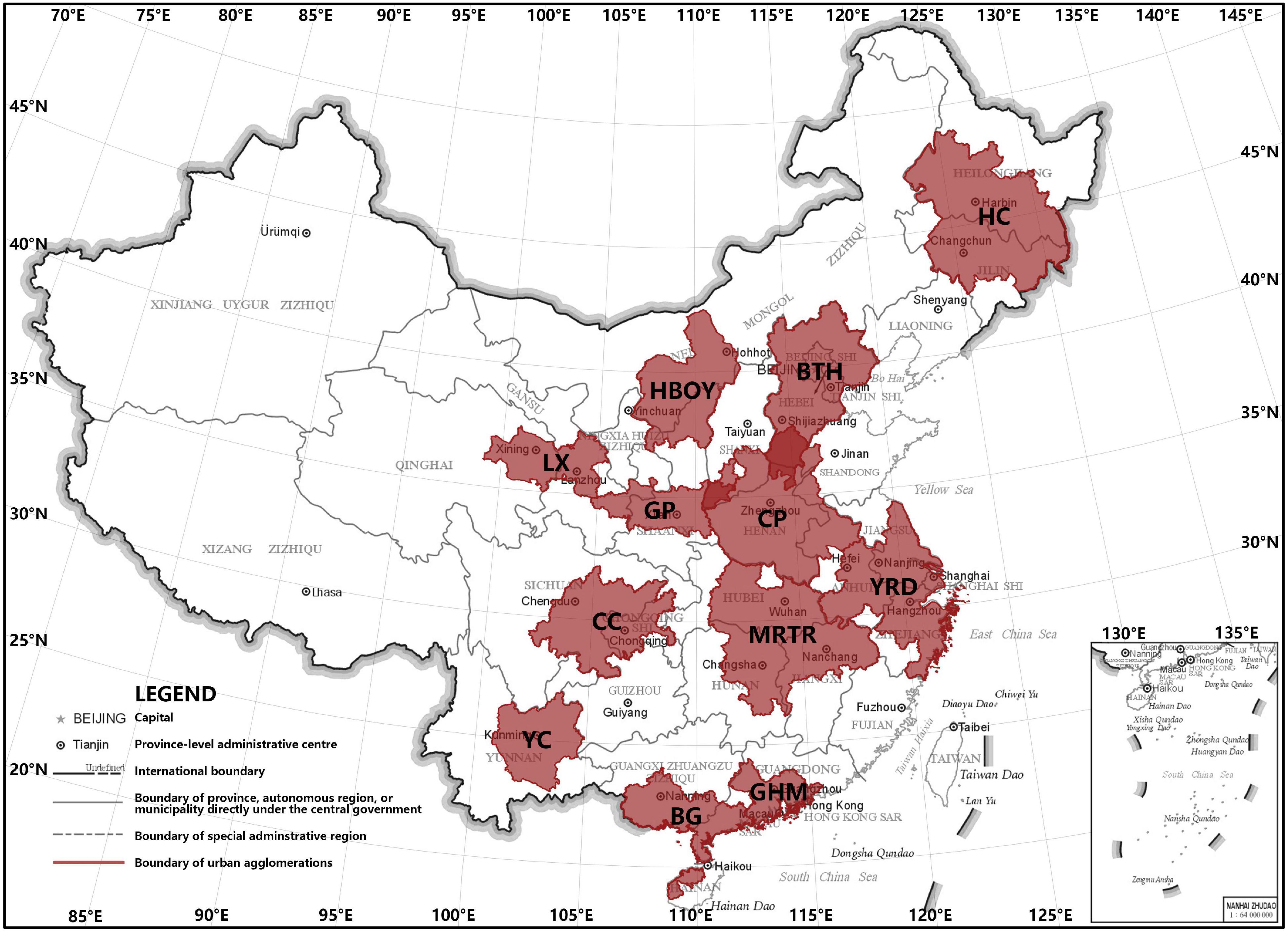
The Beijing-Tianjin-Hebei (BTH) region, one of China’s most dynamic and densely populated urban agglomerations, has undergone profound urbanization over the past two decades. This rapid development, while economically beneficial, has placed immense pressure on the regional environment, leading to air pollution, water scarcity, and ecosystem disruption. Monitoring and managing these impacts is critical for progress towards several SDGs.
- SDG 11 (Sustainable Cities and Communities): The study directly addresses the challenge of making cities inclusive, safe, resilient, and sustainable by assessing the environmental consequences of urban expansion.
- SDG 15 (Life on Land): By evaluating changes in vegetation, soil, and overall ecosystem health, the report provides critical data for efforts to protect, restore, and promote the sustainable use of terrestrial ecosystems.
- SDG 13 (Climate Action): The analysis of climatic drivers and their influence on ecological quality contributes to understanding regional climate vulnerability and informs adaptation strategies.
Methodological Framework for SDG Monitoring
To provide a robust, data-driven assessment, this study employed advanced remote sensing and statistical modeling techniques, leveraging the Google Earth Engine (GEE) platform. This approach aligns with SDG 17 (Partnerships for the Goals), which encourages the use of science, technology, and innovation for sustainable development monitoring.
Core Assessment Tools
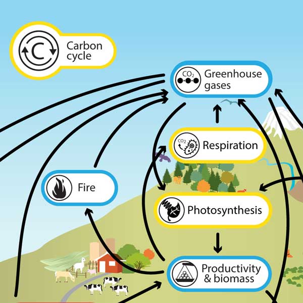
- Remote Sensing Ecological Index (RSEI): An integrated index calculated using Principal Component Analysis (PCA) to provide a comprehensive measure of eco-environmental quality. It combines four key indicators:
- Greenness (NDVI): Represents vegetation cover, crucial for SDG 15.
- Humidity (WET): Indicates moisture content in soil and vegetation.
- Temperature (LST): Measures land surface temperature, a key variable for SDG 11 and SDG 13.
- Dryness (NDBSI): Represents the extent of built-up areas and bare soil.
- Partial Least Squares Structural Equation Modeling (PLS-SEM): A statistical method used to analyze the complex causal relationships between multiple driving factors (climatic, topographical, urbanization, soil, biological) and the RSEI.
- Spatial Autocorrelation (Moran’s I): Employed to identify spatial clustering patterns, revealing how high- and low-quality ecological areas are distributed and whether environmental degradation or improvement is concentrated in specific zones.
Analysis of Findings: Progress and Setbacks for SDGs
Spatiotemporal Evolution of Eco-Environmental Quality (2000-2020)
The overall eco-environmental quality in the BTH urban agglomeration, as measured by the mean RSEI, exhibited a fluctuating decline from 2000 to 2020. This trend indicates significant challenges in balancing urban development with environmental protection, a core tenet of SDG 11 and SDG 15.
- The proportion of areas with the highest RSEI level (“Excellent”) dropped from 7.99% in 2000 to just 1.20% in 2020.
- Conversely, the proportion of areas with “Poor” and “Worst” RSEI levels showed a fluctuating upward trend, increasing from 4.80% in 2000 to 15.89% in 2020.
- A notable ecological shift was observed in 2015, where the Land Surface Temperature (LST) became a positive contributor in the principal component analysis, coinciding with a strong El Niño event. This highlights the region’s vulnerability to climatic anomalies, a key concern for SDG 13.
Driving Factors of Ecological Change
The PLS-SEM analysis identified a clear hierarchy of factors influencing the region’s eco-environmental quality. Understanding these drivers is essential for designing effective policies to advance the SDGs.
- Biological Factors: Consistently the most dominant positive influence on RSEI. This underscores the critical importance of protecting and enhancing vegetation cover (SDG 15) to maintain ecosystem health. The Normalized Difference Vegetation Index (NDVI) was the primary indicator in this category.
- Climatic Factors: Showed a variable but significant impact. While often positive, its influence turned negative in 2020, reflecting the adverse effects of extreme weather events and pollution, which poses a risk to achieving climate resilience under SDG 13.
- Soil Factors: Provided a consistent positive contribution, highlighting the role of healthy soils in supporting robust ecosystems (SDG 15.3).
- Topographical Factors: The influence of terrain shifted from slightly negative to positive over the study period, suggesting that natural landscapes increasingly serve as a buffer against the negative impacts of urban expansion.
- Urbanization Factors: Exerted a consistent and significant negative impact on eco-environmental quality. This finding directly illustrates the tension between rapid urban growth and the targets of SDG 11 for sustainable urban environments.
Spatial Clustering and Environmental Inequality
The analysis revealed distinct spatial clustering of eco-environmental quality, pointing to issues of environmental inequality within the BTH region. This is a critical consideration for SDG 11, which calls for inclusive development.
- High-High (H-H) Clusters: Areas with high ecological quality surrounded by similar areas were primarily located in the mountainous Bashang Plateau in the northern BTH region.
- Low-Low (L-L) Clusters: Areas with poor ecological quality surrounded by other poor-quality areas were concentrated in the southeastern plains, which are heavily urbanized and industrialized. These L-L clusters expanded from scattered points into more continuous regions over the two decades.
Conclusion and Policy Recommendations for SDG Acceleration
Summary of Key Challenges
The BTH urban agglomeration faces significant environmental challenges that hinder progress toward the SDGs. These include an overall trend of ecological degradation, the persistent negative pressure of urbanization, vulnerability to climatic events, and the spatial expansion of environmentally degraded zones.
Strategic Recommendations Aligned with SDGs
To reverse these trends and accelerate progress, the following integrated policy actions are recommended:
- Strengthen Coordinated Ecological Restoration (SDG 15): Implement large-scale afforestation and wetland rehabilitation projects across the BTH region to expand protective forests and ecological corridors, thereby enhancing regional vegetation cover, biodiversity, and the positive impact of biological factors.
- Enhance Joint Climate Action and Pollution Control (SDG 11 & SDG 13): Deepen collaboration between provincial authorities to create a unified early-warning system for cross-boundary air pollution and other climate-related hazards, strengthening regional resilience.
- Promote Sustainable Land Management (SDG 15.3): Undertake targeted remediation of contaminated industrial sites and degraded agricultural land. Implement soil conservation measures to increase organic matter and improve the positive contribution of soil factors to ecosystem health.
- Optimize Urban Development Patterns (SDG 11.3): Strictly enforce ecological protection red lines and urban development boundaries. Promote compact urban growth and increase the efficiency of land use to mitigate the negative impacts of urbanization.
- Implement Ecological Compensation (SDG 15 & SDG 17): Scale up ecological compensation programs for mountainous and ecologically critical areas to incentivize conservation and ensure that the benefits of ecosystem services are recognized and supported.
Analysis of Sustainable Development Goals (SDGs) in the Article
1. Which SDGs are addressed or connected to the issues highlighted in the article?
-
SDG 11: Sustainable Cities and Communities
The article directly addresses the challenges of urbanization in the Beijing-Tianjin-Hebei (BTH) urban agglomeration. It examines how “rapid and profound urbanization” has led to “increasingly severe environmental degradation,” including air pollution and ecosystem disruption. The study’s focus on evaluating the eco-environmental quality within a major urban cluster and analyzing the negative impacts of urbanization factors (like population density and land use change) clearly connects to the goal of making cities and human settlements inclusive, safe, resilient, and sustainable.
-
SDG 13: Climate Action
The study investigates the influence of climatic factors (precipitation, temperature, evapotranspiration) on the region’s eco-environmental quality. It explicitly mentions that “severe air pollution” is a major problem and that climatic events like the “strong El Niño of 2015/16” had a significant negative impact. The article also references policies like “the Joint Regional Air Pollution Control Policy,” which are measures to combat climate change and its impacts. This aligns with the need to integrate climate change measures into national policies and planning.
-
SDG 15: Life on Land
This is a central theme of the article. The entire study is an assessment of the “spatiotemporal evolution of eco-environmental quality” of terrestrial ecosystems. It discusses issues like “widespread ecosystem disruption,” soil degradation, and changes in vegetation cover (NDVI). Furthermore, it evaluates the effects of ecological restoration projects such as the “Beijing-Tianjin Sandstorm Source Control Project” and “Returning Farmland to Forests,” which are direct actions to protect, restore, and promote the sustainable use of terrestrial ecosystems and halt land degradation.
-
SDG 6: Clean Water and Sanitation
The article explicitly mentions that the dynamism of the BTH region has “accelerated… chronic water scarcity.” It also suggests policy actions like “targeted remediation of key watersheds” and implementing measures to increase “water-retention capacity.” This connects to the goal of ensuring the availability and sustainable management of water, particularly in protecting water-related ecosystems and addressing water scarcity.
2. What specific targets under those SDGs can be identified based on the article’s content?
-
SDG 11: Sustainable Cities and Communities
- Target 11.6: “By 2030, reduce the adverse per capita environmental impact of cities, including by paying special attention to air quality and municipal and other waste management.” The article’s focus on the environmental degradation caused by urbanization, particularly “severe air pollution,” and the analysis of policies aimed at controlling it, directly relates to this target.
- Target 11.3: “By 2030, enhance inclusive and sustainable urbanization and capacity for… sustainable human settlement planning and management.” The study analyzes the negative impacts of urbanization factors and concludes with recommendations for “optimizing urban spatial layouts” and enforcing “urban-development boundaries,” which are key components of sustainable urban planning.
- Target 11.a: “Support positive economic, social and environmental links between urban, peri-urban and rural areas by strengthening national and regional development planning.” The article’s focus on the “Beijing-Tianjin-Hebei (BTH) urban agglomeration” and the evaluation of the “Beijing-Tianjin-Hebei Coordinated Development Plan” directly addresses the need for integrated regional planning to balance development and environmental protection.
-
SDG 15: Life on Land
- Target 15.1: “By 2020, ensure the conservation, restoration and sustainable use of terrestrial and inland freshwater ecosystems and their services…” The entire study, which assesses the eco-environmental quality using RSEI and analyzes factors affecting it, is aligned with this target.
- Target 15.3: “By 2030, combat desertification, restore degraded land and soil… and strive to achieve a land degradation-neutral world.” The article’s analysis of the decline in eco-environmental quality, the expansion of “poor and worst RSEI levels,” and the mention of the “Beijing-Tianjin Sandstorm Source Control Project” directly address land degradation and restoration efforts.
- Target 15.2: “By 2020, promote the implementation of sustainable management of all types of forests, halt deforestation, restore degraded forests and substantially increase afforestation and reforestation globally.” The mention of ecological restoration projects like “Returning Farmland to Forests” and the suggestion to expand “protective forests” through “large-scale afforestation” are directly linked to this target.
-
SDG 13: Climate Action
- Target 13.2: “Integrate climate change measures into national policies, strategies and planning.” The article discusses the implementation and impact of policies like “the Joint Regional Air Pollution Control Policy” and “the Action Plan for Air Pollution Prevention and Control,” which represent the integration of climate-related environmental measures into regional planning.
-
SDG 6: Clean Water and Sanitation
- Target 6.6: “By 2020, protect and restore water-related ecosystems, including mountains, forests, wetlands, rivers, aquifers and lakes.” The article’s mention of “chronic water scarcity” and its recommendation to undertake “remediation of key watersheds” and “wetland rehabilitation” directly supports the protection and restoration of water-related ecosystems.
3. Are there any indicators mentioned or implied in the article that can be used to measure progress towards the identified targets?
-
Remote Sensing Ecological Index (RSEI)
This is the primary composite indicator used in the study. It serves as a comprehensive measure of eco-environmental quality and can be used to track progress towards targets under SDG 11 and SDG 15. The article provides specific values and trends for RSEI from 2000 to 2020 (e.g., “the RSEI in the BTH urban agglomeration exhibited a fluctuating downward trend”).
-
Proportion of Land Area by Ecological Quality Level
The study quantifies the percentage of land area falling into different RSEI categories (“worst,” “poor,” “moderate,” “good,” “excellent”). For example, it states that “the proportion of areas having the highest RSEI dropping from 7.99% in 2000 to 1.20% in 2020.” This directly serves as an indicator for Target 15.3 (Indicator 15.3.1: Proportion of land that is degraded over total land area).
-
Component Indices of RSEI
The individual indicators that make up the RSEI are also relevant:
- Normalized Difference Vegetation Index (NDVI): Measures “greenness” or vegetation cover. It is a direct indicator for monitoring changes in forest and vegetation area (relevant to Target 15.1 and 15.2).
- Land Surface Temperature (LST): Measures surface heat and is linked to the urban heat island effect and climate change, making it relevant for monitoring the environmental impact of cities (Target 11.6).
- Normalized Difference Built-up Index (NDBSI): Measures the extent of built-up and barren land, serving as a direct indicator of urbanization and land use change (Target 11.3).
- WET (Humidity): Indicates moisture content, which is relevant for assessing ecosystem health and water availability (Target 6.6 and 15.1).
-
Air Pollution
Although not quantified with specific metrics like PM2.5 concentrations, the article repeatedly refers to “severe air pollution” and policies for its control. This implies that air quality data is a key indicator for assessing the environmental impact of cities under Target 11.6.
-
Land Use/Cover Change
The analysis of the RSEI transfer matrix (e.g., the transition from “Good” to “Moderate” quality) is a form of land cover change analysis. This can be used to monitor the rate of land consumption versus population growth, which is relevant to Indicator 11.3.1.
4. Table of SDGs, Targets, and Indicators
| SDGs | Targets | Indicators (Mentioned or Implied in the Article) |
|---|---|---|
| SDG 11: Sustainable Cities and Communities |
11.6: Reduce the adverse per capita environmental impact of cities, especially concerning air quality.
11.3: Enhance inclusive and sustainable urbanization and planning. 11.a: Strengthen national and regional development planning. |
– Air pollution levels (implied). – Land Surface Temperature (LST) as a proxy for the urban heat island effect. – Normalized Difference Built-up Index (NDBSI) to measure urban expansion. – Rate of land use change (from RSEI transfer matrix). – Implementation of coordinated regional plans (e.g., “Beijing-Tianjin-Hebei Coordinated Development Plan”). |
| SDG 15: Life on Land |
15.1: Conserve and restore terrestrial and inland freshwater ecosystems.
15.3: Combat desertification and restore degraded land and soil. 15.2: Promote sustainable management of forests and increase afforestation. |
– Remote Sensing Ecological Index (RSEI) to measure overall ecosystem health. – Proportion of land area by ecological quality level (e.g., % of “poor” and “worst” RSEI areas). – Normalized Difference Vegetation Index (NDVI) to measure vegetation cover. – Implementation of restoration projects (“Beijing-Tianjin Sandstorm Source Control Project,” “Returning Farmland to Forests”). – Soil Organic Carbon (SOC) content. |
| SDG 13: Climate Action | 13.2: Integrate climate change measures into national policies and planning. |
– Implementation of air pollution control policies (“Joint Regional Air Pollution Control Policy”). – Analysis of climatic factors (temperature, precipitation, El Niño) as drivers of environmental change. |
| SDG 6: Clean Water and Sanitation | 6.6: Protect and restore water-related ecosystems. |
– Mention of “chronic water scarcity” as a key issue. – WET (humidity) index as a proxy for water availability in ecosystems. – Policy suggestions for “remediation of key watersheds” and “wetland rehabilitation.” |
Source: nature.com

What is Your Reaction?
 Like
0
Like
0
 Dislike
0
Dislike
0
 Love
0
Love
0
 Funny
0
Funny
0
 Angry
0
Angry
0
 Sad
0
Sad
0
 Wow
0
Wow
0