


Water–energy–food nexus: toward exploring the connection between ancient and modern science in the Indian context – Nature
Executive Summary
This report details a study investigating the scientific basis for the geographical alignment of eight prominent ancient Shiva temples along the 79°E meridian in India, known as the Shiva Shakti Aksh Rekha (SSAR). The study explores the linkage between this ancient geographical alignment and the modern water-food-energy nexus, with a significant focus on its implications for achieving United Nations Sustainable Development Goals (SDGs), particularly SDG 2 (Zero Hunger), SDG 6 (Clean Water and Sanitation), and SDG 7 (Affordable and Clean Energy). Using openly available data and statistical analysis, the study estimates the potential for water availability, food production, and renewable energy generation along the SSAR belt. Results indicate a strong positive correlation between the temple alignment and high resource productivity. The SSAR belt demonstrates a significant capacity for food production, with potential to produce 44 million tons of rice annually. Furthermore, its renewable energy generation potential is estimated at 596.6 GW, which could substantially contribute to India’s national target of 500 GW by 2030, directly supporting SDG 7. This study concludes that traditional geographical knowledge, as evidenced by the temple alignments, can offer valuable insights for contemporary resource management and strategic planning to enhance water, energy, and food security in alignment with global sustainability targets.
1.0 Introduction: Aligning Ancient Wisdom with Sustainable Development Goals
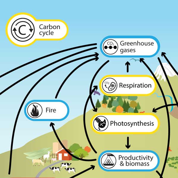
The imperative to manage water, energy, and food resources sustainably is central to the United Nations Sustainable Development Goals (SDGs), specifically SDG 2 (Zero Hunger), SDG 6 (Clean Water and Sanitation), and SDG 7 (Affordable and Clean Energy). In densely populated nations like India, which is home to 18% of the global population, the pressure on these resources is immense, making the water-energy-food (WEF) nexus a critical area of focus for policy and development. While modern scientific approaches, including remote sensing and advanced hydrological modeling, are pivotal for resource management, there is an unexplored synergy between this contemporary knowledge and the wisdom embedded in ancient civilizations.
This study bridges this gap by investigating the scientific rationale behind the precise geographical alignment of eight major Shiva temples along the 79°E meridian. The core hypothesis is that this alignment, known as the Shiva Shakti Aksh Rekha (SSAR), is not coincidental but corresponds to a region of high natural resource potential, crucial for sustaining life and fostering socioeconomic development. By analyzing the WEF nexus along this ancient axis, this report aims to provide a scientific validation of traditional geographical knowledge and highlight its relevance for achieving modern sustainable development objectives.
1.1 Study Area and Historical Context
The study focuses on a region covering approximately 50% of the Indian subcontinent, divided into three distinct belts for comparative analysis:
- Shiva Shakti Aksh Rekha (SSAR): The central belt along the 79°E meridian containing the eight prominent temples.
- SSAR West Region (SSARW): The area to the west of the SSAR belt.
- SSAR East Region (SSARE): The area to the east of the SSAR belt.
Historically, this region encompasses the ancient Deccan Plateau and parts of the Indus-Gangetic Plains, which were centers of major civilizations and dynasties. Hindu temples in ancient India were not merely places of worship but also integral hubs for education, culture, and agricultural support, contributing significantly to local socioeconomic stability and resilience.
1.2 Rationale for Temple Selection
The eight Shiva temples were selected based on the following criteria, which align with the principles of resource availability and sustainability:
- Historical and Spiritual Prominence: The temples are well-maintained and hold significant historical value, indicating sustained human settlement and resource management over centuries.
- Architectural Significance: The presence of distinct architectural features signifies substantial investment and societal importance.
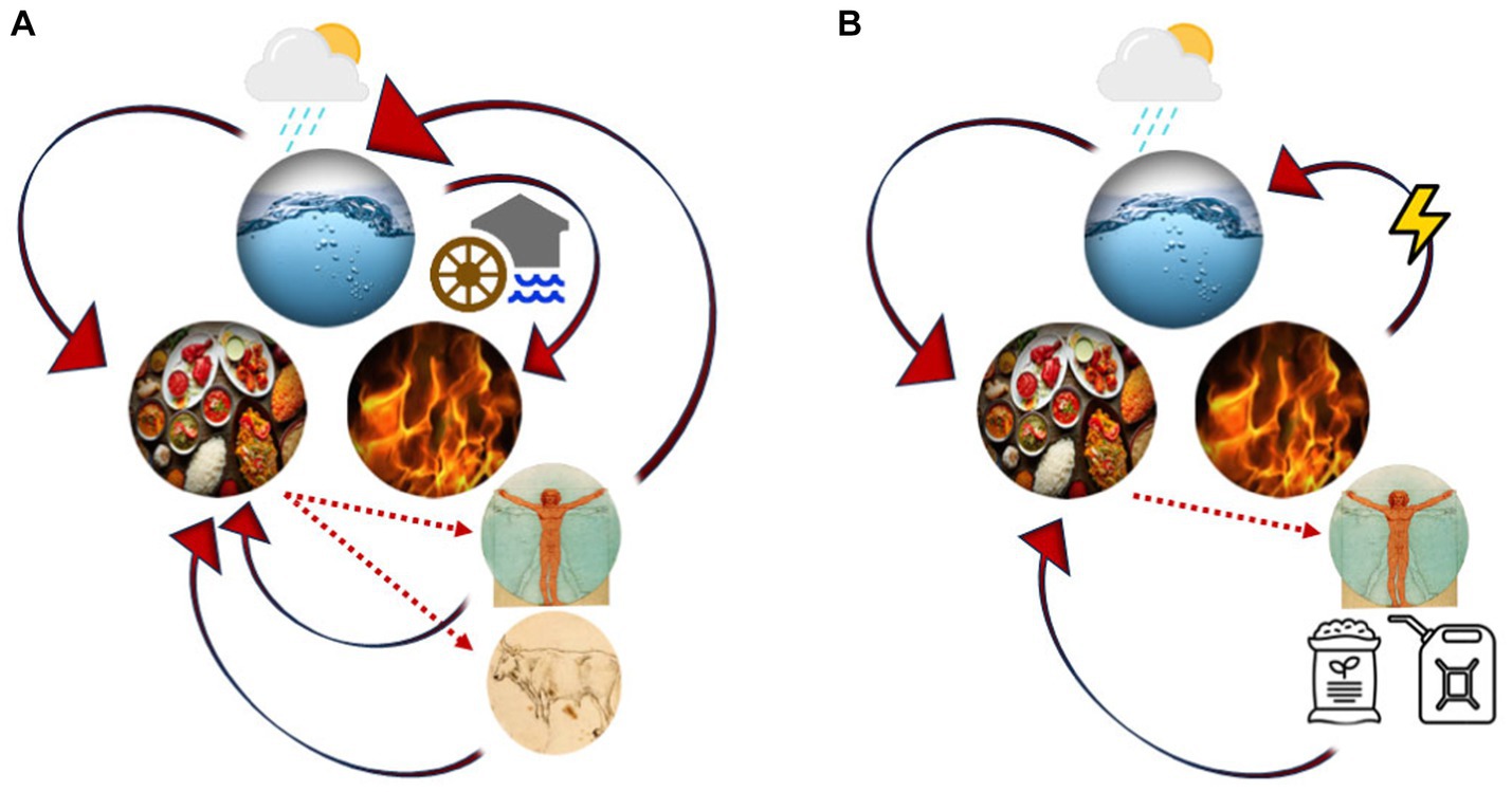
- Symbolism of Natural Elements: The temples are deeply connected to the classical elements (panchabhuta: earth, water, fire, air, sky), symbolizing a profound understanding of the natural resources essential for life, which are the foundation of the WEF nexus and related SDGs.
2.0 Analytical Framework for Assessing SDG-Related Resource Potential
To test the study’s hypothesis, a multi-criteria decision-making (MCDM) framework was developed using openly available hydrometeorological and geographical data. The methodology involved creating composite indices to quantify the potential for water, food, and energy productivity across the three designated belts.
2.1 Water and Food Productivity Analysis (SDG 2 & SDG 6)
A Water–Food Productivity Potential Index (WFPPI) was developed to assess the region’s capacity for ensuring water and food security. This analysis is directly relevant to achieving SDG 2 and SDG 6. Nine parameters were evaluated and integrated using the Analytical Hierarchy Process (AHP) and Weighted Overlay Analysis (WOA):
- Water Availability Parameters: Average annual rainfall, length-order density (LORD), and drainage density were given the highest weight, reflecting the primary importance of water for ancient civilizations and modern water security (SDG 6).
- Soil Fertility Parameters: Annual average soil loss, soil aggregate stability index (SSI), and cation exchange capacity (CEC) were analyzed to determine the land’s agricultural potential (SDG 2).
- Climate Variability Parameters: Trends in monsoon rainfall and temperature were assessed to understand climatic suitability for agriculture and potential risks.
2.2 Renewable Energy Potential Assessment (SDG 7)
A Renewable Energy Potential Index (REPI) was computed to quantify the potential for clean energy generation, a cornerstone of SDG 7. The assessment included:
- Solar Power Potential: Calculated based on global horizontal irradiance (GHI) and temperature data to estimate the maximum power generation capacity of photovoltaic (PV) cells.
- Wind Power Potential: Computed using long-term wind speed data to determine the theoretical maximum power output of wind turbines.
- Hydropower Potential: Assessed by identifying potential sites for small hydropower plants (SHPs) based on topography and river flow data.
These three potential maps were combined using an equally weighted overlay method to generate the final REPI map.
2.3 Integrated Water-Energy-Food Nexus Analysis
The final Water–Energy–Food Productivity Potential Index (WEFPPI) was created by integrating the WFPPI and REPI. This composite index provides a holistic view of the region’s resource potential, reflecting the interconnectedness of SDGs 2, 6, and 7. The reliability of all three indices (WFPPI, REPI, and WEFPPI) was validated using the Receiver Operating Characteristic (ROC) curve method, with the locations of the Shiva temples serving as ground-truth data.
3.0 Key Findings: Resource Potential and Implications for SDGs
The analysis revealed a statistically significant correlation between the geographical alignment of the eight Shiva temples and regions with high potential for water, food, and energy resources. The SSAR belt consistently demonstrated superior potential compared to the adjacent eastern and western belts.
3.1 Water and Food Productivity Potential (SDG 2 & SDG 6)
The WFPPI maps showed that the SSAR belt contains the largest area of ‘Extremely High’ and ‘Very High’ potential for water and food productivity. Key findings include:
- The SSAR belt has the potential to produce an estimated 44 million tons of rice annually, which represents a substantial contribution to India’s food security and the goal of Zero Hunger (SDG 2).
- The region’s high drainage density and rainfall contribute to enhanced water availability, supporting both agriculture and human settlement, which is fundamental to SDG 6.
- The results remained consistent across four different 30-year climate periods, indicating long-term stability in the region’s resource potential.
3.2 Renewable Energy Potential (SDG 7)
The REPI analysis highlighted the SSAR belt as a prime location for renewable energy development, directly supporting the objectives of SDG 7.
- The total renewable energy potential of the SSAR belt is estimated at 596.6 GW, comprising significant solar, wind, and hydropower resources.
- This potential far exceeds India’s national target of installing 500 GW of renewable energy capacity by 2030, positioning the SSAR belt as a strategic region for achieving national and global clean energy goals.
- The coastal regions of Tamil Nadu and the northern Ladakh region, both falling within the SSAR belt, were identified as having extremely high potential for wind and solar power generation.
3.3 Integrated Nexus and Validation
The integrated WEFPPI confirmed that the SSAR belt possesses a unique concentration of resources vital for sustainable development. The validation analysis yielded high Area Under the Curve (AUC) values (0.84 to 0.89), confirming a robust, non-random relationship between the ancient temple sites and high productivity zones for water, energy, and food.
4.0 Conclusion and Recommendations for Sustainable Development
This study provides compelling scientific evidence that the alignment of eight ancient Shiva temples along the 79°E meridian corresponds to a corridor of high water, energy, and food resource potential. This finding suggests that ancient civilizations possessed sophisticated geographical knowledge, which they utilized to establish centers of socioeconomic and cultural significance in resource-abundant locations.
The convergence of ancient wisdom and modern scientific analysis offers a powerful tool for contemporary sustainable development planning. The findings of this report can help policymakers, investors, and stakeholders make informed decisions that align with the UN SDGs.
Recommendations:
- Strategic Planning for SDGs: The WEFPPI maps should be used as a strategic tool to identify priority zones for investments in agriculture and renewable energy projects, thereby accelerating progress towards SDG 2, SDG 6, and SDG 7.
- Climate-Resilient Agriculture: Given the high food productivity potential, the SSAR belt should be a focus for developing climate-resilient agricultural practices to ensure long-term food security.
- Renewable Energy Hubs: The identified high-potential solar and wind zones within the SSAR belt should be developed as renewable energy hubs to help India transition away from fossil fuels and meet its climate action commitments (SDG 13).
- Integration of Traditional Knowledge: This study demonstrates the value of integrating traditional and indigenous knowledge into modern scientific frameworks for sustainable resource management. Further research should explore other instances of ancient geographical alignments to uncover additional insights for sustainable development.
By leveraging the insights from this unique intersection of history, science, and sustainability, India can better navigate the complexities of the water-energy-food nexus and build a more resilient and sustainable future for its population.
Analysis of Sustainable Development Goals in the Article
1. Which SDGs are addressed or connected to the issues highlighted in the article?
-
SDG 2: Zero Hunger
- The article directly addresses food security and agricultural productivity. It explicitly mentions “food production” and the “water-food-energy nexus.” The study estimates the “water–food productivity potential,” calculating that a specific area “can produce 44 × 10^6 tons of rice annually.” This focus on enhancing food production capacity and identifying fertile regions is central to achieving zero hunger.
-
SDG 6: Clean Water and Sanitation
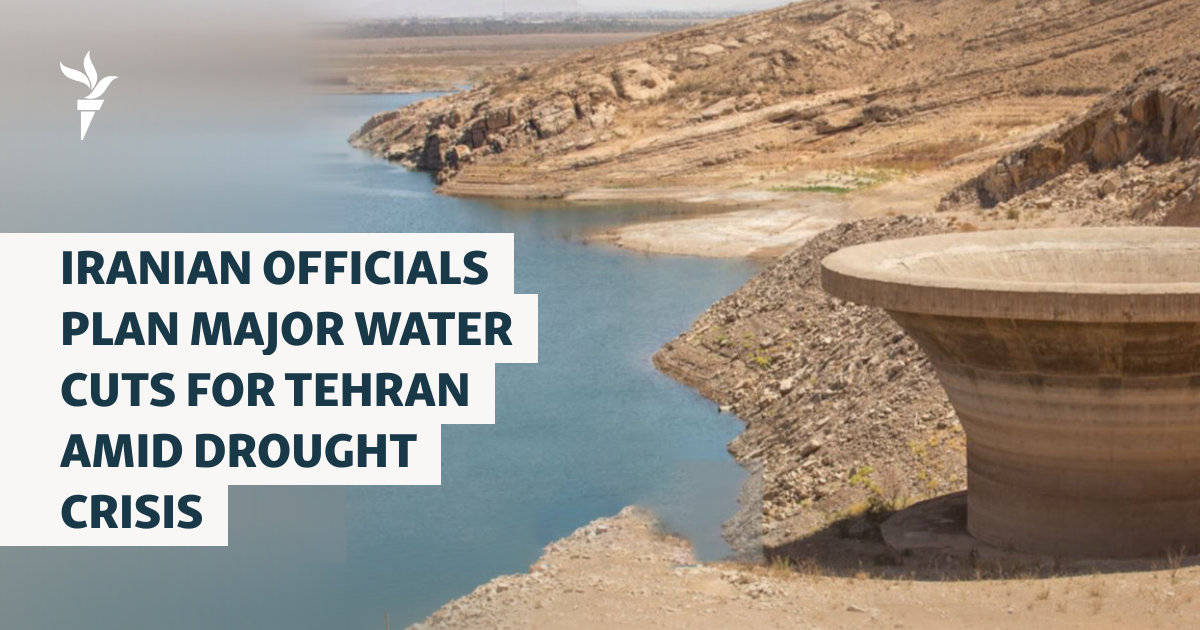
- Water is a core theme of the article, which investigates the “water–food–energy potential.” The introduction highlights the importance of managing water resources and understanding its role as an “enabler of food and energy security.” The analysis relies on hydrological variables and aims to support “future water…security,” which aligns directly with the goals of SDG 6 concerning water availability and sustainable management.
-
SDG 7: Affordable and Clean Energy
- The article extensively analyzes the potential for renewable energy generation, including solar, wind, and hydropower. It quantifies this potential, stating that the “SSAR belt could significantly contribute to India’s target of 500 GW of renewable energy production by 2030” with an “estimated renewable energy generation potential of 596.6 GW.” This directly connects to the goal of increasing the share of renewable energy in the energy mix.
2. What specific targets under those SDGs can be identified based on the article’s content?
-
Under SDG 2 (Zero Hunger):
- Target 2.4: “By 2030, ensure sustainable food production systems and implement resilient agricultural practices that increase productivity and production…” The article supports this target by developing a “water–food productivity potential index (WFPPI)” to identify optimal locations for “agricultural farms.” This analysis helps in planning for sustainable and productive agriculture.
-
Under SDG 6 (Clean Water and Sanitation):
- Target 6.5: “By 2030, implement integrated water resources management at all levels…” The study’s entire premise is based on an integrated “water–energy–food nexus” approach. By creating a “water–energy–food productivity potential index (WEFPPI),” the research provides a framework for integrated management of these interconnected resources, which is the essence of this target.
-
Under SDG 7 (Affordable and Clean Energy):
- Target 7.2: “By 2030, increase substantially the share of renewable energy in the global energy mix.” The article directly addresses this target by estimating the renewable energy potential of the studied region. It explicitly states that the “SSAR belt could significantly contribute to India’s target of 500 GW of renewable energy production by 2030,” providing a clear pathway to increasing the share of clean energy.
3. Are there any indicators mentioned or implied in the article that can be used to measure progress towards the identified targets?
-
For SDG 2 (Target 2.4):
- Indicator: Agricultural Output/Yield. The article provides a specific metric for food production potential: “18.5% of the area can produce 44 × 10^6 tons of rice annually.” This quantifiable output serves as a direct indicator of agricultural productivity, which is used to measure progress toward sustainable food production systems.
-
For SDG 6 (Target 6.5):
- Indicator: Water Availability and Runoff. While not a formal SDG indicator, the article uses key hydrological metrics to assess water resources, which are foundational for integrated management. It mentions “average annual rainfalls of 870, 940, and 1130 mm” and calculates that the study area “can generate 976 km³/year of water, of which 345 km³/year is utilizable.” These figures are used to measure the water component of the nexus.
-
For SDG 7 (Target 7.2):
- Indicator: Renewable Energy Generation Capacity. The article directly provides data that can be used to measure the share of renewable energy. It estimates the “renewable energy generation potential of 596.6 GW” and explicitly references “India’s target of 500 GW of renewable energy production by 2030.” This potential capacity is a direct measure of progress toward increasing the share of renewable energy (Indicator 7.2.1).
4. Create a table with three columns titled ‘SDGs, Targets and Indicators” to present the findings from analyzing the article. In this table, list the Sustainable Development Goals (SDGs), their corresponding targets, and the specific indicators identified in the article.
| SDGs | Targets | Indicators |
|---|---|---|
| SDG 2: Zero Hunger | Target 2.4: Ensure sustainable food production systems and implement resilient agricultural practices. | Agricultural Output/Yield: Potential to produce “44 × 10^6 tons of rice annually” in the high-potential zones of the SSAR belt. |
| SDG 6: Clean Water and Sanitation | Target 6.5: Implement integrated water resources management at all levels. | Water Availability and Runoff: Analysis of “average annual rainfall” and “utilizable” surface water (345 km³/year). The development of the WEFPPI serves as a tool for integrated management. |
| SDG 7: Affordable and Clean Energy | Target 7.2: Increase substantially the share of renewable energy in the global energy mix. | Renewable Energy Generation Capacity: An estimated potential of “596.6 GW” from renewable sources, contributing to India’s national target of “500 GW… by 2030.” |
Source: nature.com

What is Your Reaction?
 Like
0
Like
0
 Dislike
0
Dislike
0
 Love
0
Love
0
 Funny
0
Funny
0
 Angry
0
Angry
0
 Sad
0
Sad
0
 Wow
0
Wow
0