USDA’s Disaster Mapping Team Provides Data in the Most Critical Times
USDA's Disaster Mapping Team Provides Data in the Most Critical ... USDA.gov


Disaster Mapping Team Supports Sustainable Development Goals
Posted by Terry Matlock, Public Affairs Specialist, National Agricultural Statistics Service
Date: September 20, 2023
As we observe September as National Preparedness Month, it is important to remember that being prepared is the most important thing you can do to assist in dealing with any disaster or emergency. Unfortunately, no amount of preparation will stop a natural disaster or emergency from occurring, but how you react to them can be just as critical. This is why the U.S. Department of Agriculture’s National Agricultural Statistics Service (NASS) created a Disaster Mapping Team.
The Disaster Mapping Team monitors agricultural disasters in near-real time and provides quantitative assessments of affected agricultural land using remotely sensed data and geospatial techniques. These essential data support prompt decision making about emergency assistance, food security, and crop insurance programs.
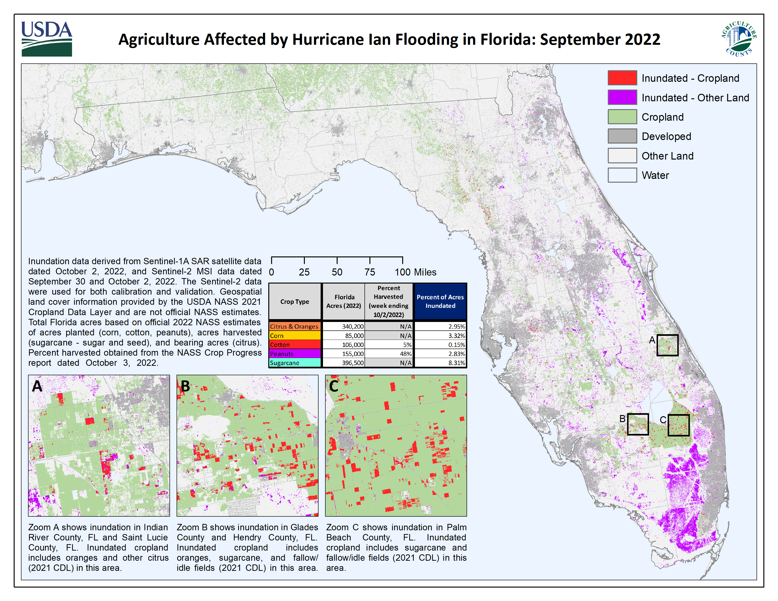
From hurricanes, floods, and wildfires to derechos, droughts, and tornadoes, NASS provides assessment reports, maps, geospatial data, and metadata on weather events to the public. These products assist internal and external stakeholders in estimating the economic impact of disasters on their agricultural sectors, assist state emergency boards in gauging the long-term extents of damage, help to understand implications on livestock and feeding operations, and support the USDA Multiagency Coordination Team during response and recovery. This work is made possible by using timely, openly available geospatial data and a cloud computing platform.
The Disaster Mapping Team allows NASS to fill a critical need and provide timely, accurate, and useful statistics in service to U.S. Agriculture. More information is available on the NASS Disaster Analysis web page at www.nass.usda.gov/Research_and_Science/Disaster-Analysis/index.php.
Sustainable Development Goals (SDGs)
- Goal 1: No Poverty
- Goal 2: Zero Hunger
- Goal 3: Good Health and Well-being
- Goal 6: Clean Water and Sanitation
- Goal 11: Sustainable Cities and Communities
- Goal 13: Climate Action
- Goal 15: Life on Land
You May Also Like
SDGs, Targets, and Indicators Analysis
1. Which SDGs are addressed or connected to the issues highlighted in the article?
- SDG 1: No Poverty – The article mentions that the Disaster Mapping Team’s work supports prompt decision making about emergency assistance and food security programs.
- SDG 2: Zero Hunger – The article states that the Disaster Mapping Team’s work supports decision making about emergency assistance and crop insurance programs.
- SDG 11: Sustainable Cities and Communities – The article mentions that NASS provides assessment reports, maps, and geospatial data on weather events to assist state emergency boards in gauging long-term extents of damage.
- SDG 13: Climate Action – The article discusses monitoring agricultural disasters caused by hurricanes, floods, wildfires, derechos, droughts, and tornadoes, which are all related to climate change.
2. What specific targets under those SDGs can be identified based on the article’s content?
- Target 1.5: By 2030, build the resilience of the poor and those in vulnerable situations and reduce their exposure and vulnerability to climate-related extreme events and other economic, social, and environmental shocks and disasters.
- Target 2.4: By 2030, ensure sustainable food production systems and implement resilient agricultural practices that increase productivity and production, that help maintain ecosystems, that strengthen capacity for adaptation to climate change, extreme weather, drought, flooding, and other disasters, and that progressively improve land and soil quality.
- Target 11.5: By 2030, significantly reduce the number of deaths and the number of people affected and substantially decrease the direct economic losses relative to global gross domestic product caused by disasters, including water-related disasters, with a focus on protecting the poor and people in vulnerable situations.
- Target 13.1: Strengthen resilience and adaptive capacity to climate-related hazards and natural disasters in all countries.
3. Are there any indicators mentioned or implied in the article that can be used to measure progress towards the identified targets?
- Indicator 1.5.1: Number of deaths, missing persons, and directly affected persons attributed to disasters per 100,000 population.
- Indicator 2.4.1: Proportion of agricultural area under productive and sustainable agriculture.
- Indicator 11.5.1: Number of deaths, missing persons, and directly affected persons attributed to disasters per 100,000 population.
- Indicator 13.1.1: Number of deaths, missing persons, and directly affected persons attributed to disasters per 100,000 population.
SDGs, Targets, and Indicators Table
| SDGs | Targets | Indicators |
|---|---|---|
| SDG 1: No Poverty | Target 1.5: By 2030, build the resilience of the poor and those in vulnerable situations and reduce their exposure and vulnerability to climate-related extreme events and other economic, social, and environmental shocks and disasters. | Indicator 1.5.1: Number of deaths, missing persons, and directly affected persons attributed to disasters per 100,000 population. |
| SDG 2: Zero Hunger | Target 2.4: By 2030, ensure sustainable food production systems and implement resilient agricultural practices that increase productivity and production, that help maintain ecosystems, that strengthen capacity for adaptation to climate change, extreme weather, drought, flooding, and other disasters, and that progressively improve land and soil quality. | Indicator 2.4.1: Proportion of agricultural area under productive and sustainable agriculture. |
| SDG 11: Sustainable Cities and Communities | Target 11.5: By 2030, significantly reduce the number of deaths and the number of people affected and substantially decrease the direct economic losses relative to global gross domestic product caused by disasters, including water-related disasters, with a focus on protecting the poor and people in vulnerable situations. | Indicator 11.5.1: Number of deaths, missing persons, and directly affected persons attributed to disasters per 100,000 population. |
| SDG 13: Climate Action | Target 13.1: Strengthen resilience and adaptive capacity to climate-related hazards and natural disasters in all countries. | Indicator 13.1.1: Number of deaths, missing persons, and directly affected persons attributed to disasters per 100,000 population. |
Behold! This splendid article springs forth from the wellspring of knowledge, shaped by a wondrous proprietary AI technology that delved into a vast ocean of data, illuminating the path towards the Sustainable Development Goals. Remember that all rights are reserved by SDG Investors LLC, empowering us to champion progress together.
Source: usda.gov
![]()
Join us, as fellow seekers of change, on a transformative journey at https://sdgtalks.ai/welcome, where you can become a member and actively contribute to shaping a brighter future.


