Mapping previously undetected trees reveals overlooked changes in pan-tropical tree cover – Nature
Report on Pan-Tropical Tree Cover Mapping and Dynamics with Emphasis on Sustainable Development Goals (SDGs)
Introduction
Climate change and human activities significantly impact tree dynamics, affecting global carbon stocks, biodiversity, hydrology, and climate regulation. Pan-tropical trees contribute critically to these functions. Traditional forest definitions often exclude trees outside dense forests, such as urban trees and those in woodlands and arid regions, which also provide essential ecosystem services and climate mitigation benefits. Mapping and monitoring these trees are vital for achieving several Sustainable Development Goals (SDGs), including SDG 13 (Climate Action), SDG 15 (Life on Land), and SDG 11 (Sustainable Cities and Communities).
Methodology
- Data Acquisition: High-resolution satellite imagery (
- Automatic Detection Algorithm: A novel framework combining decision tree classification, automatic clustering of random sample points, and machine learning (random forest) was developed to identify tree crowns across pan-tropical regions.
- Sample Generation and Cleaning: Stratified sampling extracted 500 sample points per 500×500 m grid, followed by rigorous cleaning based on spectral characteristics to ensure high-quality training data.
- Mapping and Validation: The random forest model was trained and applied to generate annual tree cover maps, validated with over 150,000 sample points achieving an overall accuracy of 97.31%.
- Change Detection and Analysis: Tree cover changes between 2015–2018 and 2019–2022 were analyzed, with sensitivity analysis quantifying contributions from climate factors (precipitation), human activities (population density), and land use/cover change (LUCC).
Key Findings
High-Resolution Pan-Tropical Tree Cover Mapping
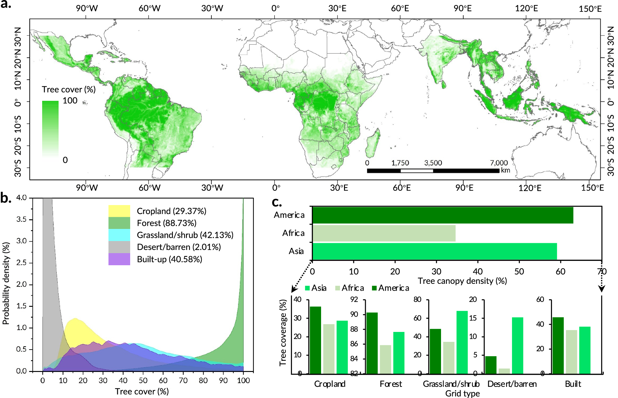
- Total pan-tropical tree cover area is approximately 2,286.74 million hectares (Mha), with 53.37% located outside traditional forest grids.
- Tree cover ratios vary by land type: forests (88.73%), shrub/grassland (42.13%), built-up areas (40.58%), croplands (29.37%), and bare land/deserts (2.00%).
- Regional differences show Americas having the highest average tree cover, followed by Asia and Africa.
Previously Undetected Tree Cover (PUTC)
- PUTC accounts for 17.31% ± 1.78% of total pan-tropical tree cover, highlighting significant underestimation in existing datasets.
- PUTC is predominantly found in non-forest areas, especially shrub/grassland (15.11%), cropland (2.15%), bare land/desert (0.40%), and built-up areas (0.08%).
- Continental variations include high PUTC in African shrub/grasslands (26.27%) and Asian croplands (4.41%).
Tree Cover Dynamics (2015–2022)
- Net decrease of 61.05 ± 2.36 Mha in tree cover, with 63.93% loss in forest grids and 36.07% in non-forest grids.
- Gross loss (67.24 ± 2.05 Mha) far exceeds gross gain (6.19 ± 2.56 Mha), indicating a net decline.
- Major loss areas include tropical rainforests in Mato Grosso, Laos, and Congo, consistent with global forest change datasets.
- Non-forest grids contribute significantly to net loss, especially in Africa and the Americas.
Driving Factors of Tree Cover Change
- Land Use/Cover Change (LUCC) is the dominant driver, accounting for 53.93% of tree cover loss.
- Climate change, primarily increased precipitation, is associated with 43.98% of tree cover gain.
- Human activities (planting, cutting) contribute to 2.10% of tree cover loss, with notable impacts in cropland and built-up areas.
- Spatial analysis reveals that areas with high PUTC experience more significant tree cover changes, emphasizing the importance of fine-scale mapping.
- Threshold effects exist for population density (~23 people/km²) and precipitation (750 mm and 1300 mm), influencing tree cover distribution and dynamics.
Discussion and Implications for Sustainable Development Goals
This study advances the mapping of pan-tropical tree cover by incorporating previously undetected trees, crucial for achieving multiple SDGs:
- SDG 13 (Climate Action): Accurate tree cover mapping enhances understanding of carbon sequestration and supports climate mitigation strategies by revealing overlooked carbon sinks and degradation patterns.
- SDG 15 (Life on Land): Inclusion of trees outside forests informs biodiversity conservation, ecosystem service provision, and sustainable land management.
- SDG 11 (Sustainable Cities and Communities): Mapping urban and cropland trees supports urban planning and sustainable agriculture, promoting resilience and livelihoods.
- SDG 2 (Zero Hunger): Trees in agricultural landscapes contribute to food security through ecosystem services.
The integration of machine learning with high-resolution satellite data enables scalable, objective, and rapid monitoring of tree cover changes, addressing previous limitations in global forest monitoring systems. The findings underscore the urgency of incorporating fine-scale tree cover data into international forest management policies and climate commitments such as the Glasgow Declaration and Bonn Challenge.
Conclusions
- Approximately 17.31% of pan-tropical tree cover is previously undetected, predominantly outside traditional forest areas.
- There is a net loss of tree cover from 2015 to 2022, driven mainly by land use changes and human activities, partially offset by gains linked to increased precipitation.
- Fine-scale mapping of tree cover, including individual trees, is essential for accurate carbon accounting, biodiversity conservation, and sustainable land management aligned with SDGs.
- Automated machine learning approaches provide effective tools for global-scale, high-resolution tree cover monitoring, supporting evidence-based policy and climate action.
Data and Code Availability
- Tree cover data and change datasets are publicly available via the World Cover dataset (ESA), MODIS Global Land Cover Products, and NICFI mosaics on Google Earth Engine.
- Population density and precipitation datasets used as proxies for human activities and climate change are accessible through respective public repositories.
- All code and methodological details for tree crown detection and analysis are available on Zenodo: https://doi.org/10.5281/zenodo.14892757.
1. Sustainable Development Goals (SDGs) Addressed or Connected
- SDG 13: Climate Action
- The article discusses tree cover detection for climate mitigation and highlights the role of trees in carbon cycling and climate change mitigation.
- It emphasizes the impact of climate change on tropical forests and the importance of monitoring tree cover changes to combat climate degradation.
- SDG 15: Life on Land
- The study focuses on sustainable land management through mapping pan-tropical tree cover, including forests and trees outside forests.
- It addresses forest degradation, deforestation, and the importance of biodiversity conservation.
- SDG 2: Zero Hunger
- The article mentions the ecological benefits of trees in croplands and their role in food security and livelihoods.
- SDG 11: Sustainable Cities and Communities
- It includes the detection and monitoring of trees in built-up areas, contributing to urban sustainability.
2. Specific Targets Under Identified SDGs
- SDG 13: Climate Action
- Target 13.1: Strengthen resilience and adaptive capacity to climate-related hazards and natural disasters.
- Target 13.2: Integrate climate change measures into national policies, strategies, and planning.
- SDG 15: Life on Land
- Target 15.1: Ensure the conservation, restoration, and sustainable use of terrestrial and inland freshwater ecosystems and their services.
- Target 15.2: Promote the implementation of sustainable management of all types of forests, halt deforestation, restore degraded forests, and increase afforestation and reforestation globally.
- Target 15.3: Combat desertification, restore degraded land and soil, including land affected by desertification, drought, and floods.
- SDG 2: Zero Hunger
- Target 2.4: Ensure sustainable food production systems and implement resilient agricultural practices that increase productivity and production.
- SDG 11: Sustainable Cities and Communities
- Target 11.7: Provide universal access to safe, inclusive, and accessible green and public spaces, particularly for vulnerable populations.
3. Indicators Mentioned or Implied to Measure Progress
- Tree Cover Area and Change
- Percentage and area of pan-tropical tree cover (total area of 2286.74 Mha with 17.31% previously undetected tree cover).
- Net change in tree cover area between 2015 and 2022 (net decrease of 61.05 ± 2.36 Mha).
- Gross loss and gain of tree cover (gross loss 67.24 ± 2.05 Mha, gross gain 6.19 ± 2.56 Mha).
- Proportion of tree cover in different land cover types (forest, cropland, built-up areas, shrub/grassland, bare land/desert).
- Previously Undetected Tree Cover (PUTC)
- Proportion of PUTC relative to total tree cover (17.31 ± 1.78%).
- Distribution of PUTC across different grid types and continents.
- Contributions of Driving Factors
- Percentage contributions of climate change (precipitation), human activities (population density), and land use/cover change (LUCC) to tree cover changes.
- Quantified contributions: 43.98% of tree cover gain linked to increased precipitation; 56.03% of tree cover loss associated with anthropogenic impacts (LUCC and human activities).
- Accuracy and Validation Metrics
- Overall accuracy of tree cover mapping (97.31%).
- Precision (96.64%), recall (98.82%), and F1 score (0.9772) for tree and non-tree regions.
- Mapping accuracy of tree cover change (92.47%).
4. Table of SDGs, Targets, and Indicators
| SDGs | Targets | Indicators |
|---|---|---|
| SDG 13: Climate Action |
|
|
| SDG 15: Life on Land |
|
|
| SDG 2: Zero Hunger |
|
|
| SDG 11: Sustainable Cities and Communities |
|
|
Source: nature.com
![]()


