Forest Park


Forest Park: An Urban Wilderness

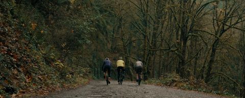
Forest Park’s trails offer fun all year long.
With 70 miles (113 km) of trails, aptly named Forest Park is a popular escape for runners, cyclists, equestrians, and hikers alike — leashed dogs are even allowed to enjoy its splendor. Located in the city’s northwest corner, this 8-mile-long (13 km) conservancy covers 5,156 acres (2,086 ha), providing a respite from urban life, supporting more than 112 bird and 62 mammal species and acting as a natural air purifier.
A favorite route is the 30-mile (48 km) Wildwood Trail, which spans the entire length of Forest Park, connecting it with the Audubon Society Sanctuary, Pittock Mansion, and Washington Park through the region’s 40-Mile Loop system of trails. The pathway can be accessed just northwest of the Washington Park MAX station and offers endless loop options with shorter paths, so you don’t have to commit to the whole thing. The park can also be accessed from several points in the Northwest Portland neighborhood; an entrance up Northwest Thurman Street leads to Leif Erikson Drive, a favorite road for exploring the park’s wooded hills.
The most popular trail in Forest Park is the scenic 5-mile (8 km) round trip trek from Lower Macleay Park to the Pittock Mansion. Macleay Park, located at the west end of Northwest Upshur Street just past 29th Avenue, provides an easily accessible starting point. Follow the Lower Macleay Trail, which traces Balch Creek, the park’s largest stream, into a thickly wooded ravine.
One mile up the trail, where it intersects the Wildwood Trail, visit the moss-covered remains of a stone building erected by the Works Progress Administration in 1936. (Known by locals as the “Stone House” or “Witch’s Castle,” the structure is, in fact, a former restroom.) Continue straight on the Wildwood Trail, still following Balch Creek, and begin a leg-pumping ascent to Upper Macleay Park. (A smattering of picnic tables and a port-a-potty make this an ideal rest stop.) The Bird Alliance of Oregon, with its free interpretive center and wildlife rehabilitation facility housing owls, red-tailed hawks, and more, provides an inviting detour nearby. For the final leg, continue across Northwest Cornell Road and stay on the Wildwood Trail, which snakes upward on a .5-mile (.8 km) climb through a quiet canopy of towering firs to reach Pittock Mansion. Set nearly 1,000 feet (304 m) above the city, the 100-year-old home of 10th-century newspaper tycoon Henry Pittock features immaculate gardens and sweeping downtown views — a fitting reward for an afternoon on the trail.
These public outdoor spaces are beloved spots for biking, running, picnicking and more.
These public outdoor spaces are beloved spots for biking, running, picnicking and more.
Was this page helpful?
Escape the city without leaving Portland in this massive urban wilderness that’s a haven for animals and adventurers alike.
Overview
Wildwood Trail
Macleay Park Trail
Final Leg
More Portland Parks
Useful Links
Mentioned Elsewhere Online
More Portland Parks
Feedback
Advertisements
SDGs, Targets, and Indicators
SDGs, Targets, and Indicators
- SDG 15: Life on Land
- Target 15.1: By 2020, ensure the conservation, restoration, and sustainable use of terrestrial and inland freshwater ecosystems and their services, in particular forests, wetlands, mountains, and drylands, in line with obligations under international agreements.
- Indicator 15.1.1: Forest area as a proportion of total land area.
- Target 11.7: By 2030, provide universal access to safe, inclusive, and accessible, green and public spaces, in particular for women and children, older persons, and persons with disabilities.
- Indicator 11.7.1: Average share of the built-up area of cities that is open space for public use for all, by sex, age, and persons with disabilities.
Explanation
1. SDG 15: Life on Land is addressed in the article through the discussion of Forest Park, which is a conservancy that covers 5,156 acres of land and supports various species of birds and mammals. This aligns with Target 15.1, which aims to ensure the conservation, restoration, and sustainable use of terrestrial ecosystems. The indicator mentioned in the article is Indicator 15.1.1, which measures the forest area as a proportion of total land area.
2. SDG 11: Sustainable Cities and Communities is connected to the article’s content as Forest Park provides a green and public space within the city of Portland. This relates to Target 11.7, which aims to provide universal access to safe, inclusive, and accessible green and public spaces. The indicator mentioned in the article is Indicator 11.7.1, which measures the average share of the built-up area of cities that is open space for public use.
Table: SDGs, Targets, and Indicators
| SDGs | Targets | Indicators |
|---|---|---|
| SDG 15: Life on Land | Target 15.1: By 2020, ensure the conservation, restoration, and sustainable use of terrestrial and inland freshwater ecosystems and their services, in particular forests, wetlands, mountains, and drylands, in line with obligations under international agreements. | Indicator 15.1.1: Forest area as a proportion of total land area. |
| SDG 11: Sustainable Cities and Communities | Target 11.7: By 2030, provide universal access to safe, inclusive, and accessible, green and public spaces, in particular for women and children, older persons, and persons with disabilities. | Indicator 11.7.1: Average share of the built-up area of cities that is open space for public use for all, by sex, age, and persons with disabilities. |
Source: travelportland.com


