Arizona groundwater regulation weaknesses exploited by industrial-scale agriculture
Arizona groundwater regulation weaknesses exploited by industrial-scale agriculture Arizona Mirror

Report: Groundwater Regulation Weaknesses Exploited by Industrial-Scale Agriculture
ELFRIDA, Ariz. — Elaine Bailey stood at the microphone at the Sunsites Community Center in southeastern Arizona, voice shaking as she described the massive scale of new agricultural development next to her property. The nearby fields have drawn so much water from the surrounding area, she said, that her well has gone dry.
Concerns about Groundwater in Sulphur Springs Valley
“Here we are, all these good people fighting for our lives, our homes, our everything,” Bailey said. “Because if the water goes, our homes aren’t worth anything. That’s the reality. And I just don’t understand how the state can even allow it.”
“I don’t, either,” replied Arizona Attorney General Kris Mayes, who visited the small community in February to hear residents’ concerns about the groundwater in Sulphur Springs Valley—home to the Willcox and Douglas groundwater basins.
Increase in Agricultural Development Despite Restrictions
The Douglas basin has seen agricultural development explode in recent years, despite two major attempts to limit groundwater usage in the region: In 1980, it was designated an Irrigation Non-expansion Area, barring the addition of new irrigated land, and in 2022, it became an Active Management Area, which carries the state’s most stringent level of groundwater regulation.
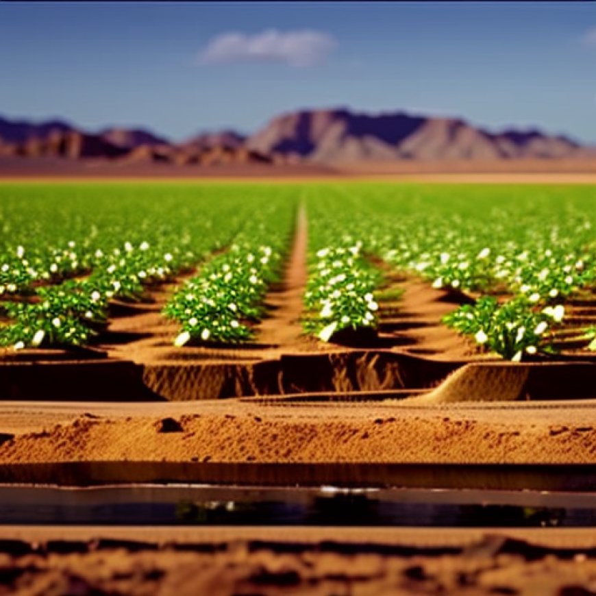
Yet over the past 15 years, even with these restrictions in effect, at least several thousand acres of dormant farmland have again started siphoning groundwater to sustain new crops, an AZCIR analysis has found. The increase in pumping, at an intensity not previously seen in the basin, is largely under industrial-scale owners that have consolidated the land, and the grandfathered water rights tied to it, into massive operations. The analysis, which matched federal satellite data to local property records, also shows new irrigation occurring on land that had never previously been cultivated.
Impact of Water-Intensive Practices
The resulting groundwater declines have accelerated the most on properties closest to these large-sale farms, which have embraced more water-intensive practices like double cropping, or harvesting multiple crops on the same field throughout the year. The number of acres using this method has grown by more than 600% in the Douglas basin since 2008, AZCIR’s analysis also found.
Loopholes and Violations
Residents contend some of these well-financed agricultural players are exploiting loopholes in existing regulations, and that some could be outright violating them. Regardless of the legality of the maneuvers, the industrial farms have expanded, often at the expense of their smaller neighbors. North of Elfrida, Ariz., for instance, where much of the growth has occurred, water levels in some wells have dropped by more than four feet per year—a statistic that drew gasps at the Sunsites Community Center.
Effectiveness of Existing Regulatory Tools
It is broadly acknowledged that without current and past regulations, the situation in the Douglas basin would be much worse. But residents’ experiences, backed by mounting data, raise questions about whether existing regulatory tools are effective enough to protect the aquifer in the long term. And as the basin’s groundwater continues to decline, residents’ confidence in the ability of the Arizona Department of Water Resources to protect their sole supply of water dwindles alongside it.
Concerns for Basins Across the State
Statewide, the number of basins facing similar groundwater restrictions is growing for the first time in 40 years. Short of meaningful intervention by the Arizona Legislature, however, experts and residents worry the same regulatory shortfalls seen in this Cochise County basin will play out across the state, with well-financed, large-scale agriculture taking advantage of existing policies at the cost of locals who don’t have the resources or government backing to do more.
Legislative Failures
Mayes, who collected Rabin and Bailey’s contact information to further investigate their claims, blames the Legislature because it has not passed meaningful groundwater regulation in decades.
“This Legislature has failed all of us,” Mayes told residents in February. The room erupted with applause.
Grandfathered Rights and Consolidation of Land
When the Douglas basin was established as an Irrigation Non-expansion Area (INA) in 1980, the designation limited the expansion of irrigated farmland while allowing those already watering crops to continue doing so. As long as landowners had irrigated at any point in the five years leading up to the new regulation, they were grandfathered into the new system, meaning they could use groundwater to grow crops moving forward.
But these grandfathered rights are tied to the land, not the user. Even if a parcel stops being farmed, subsequent owners have the right to irrigate again at any time.
Industrial-scale farms that have settled in Cochise County since the INA was established, often from out of state, have done just that. And because the INA capped only the number of acres being irrigated—not the amount of water any one landowner can use—it enabled these operations to purchase land with grandfathered irrigation rights and deploy intensive irrigation practices like double cropping.
Exploiting Provision in State Law
Dormant land purchased with grandfathered irrigation rights is a primary reason for recent growth in the Douglas basin’s active farmland, but it is not the only one. A small provision in the state law also allows owners to swap irrigation rights from cropland that can’t be irrigated efficiently into new acres elsewhere.
Most irrigation rights were initially assigned to rectangular fields that were flood-irrigated, a method that immerses a field so water can be absorbed into the soil. But as farmers switched to more efficient center pivot irrigation, which allows more control of how much water is applied by a sprinkler arm rotating in a circle, the corners of these fields were often left uncultivated.
In 2018, White Brothers Grain, one of the biggest farms in the Douglas basin, filed an application to voluntarily give up rights to irrigate the corners in some of its fields. In exchange, the company added new acreage that equaled the size of the corners it retired from irrigation. The Arizona Department of Water Resources signed off on the swap, and soon after, other farms such as Riverview followed its lead.
Concerns and Investigations
Residents contend some of these well-financed agricultural players are exploiting loopholes in existing regulations, and that some could be outright violating them. Regardless of the legality of the maneuvers, the industrial farms have expanded, often at the expense of their smaller neighbors. North of Elfrida, Ariz., for instance, where much of the growth has occurred, water levels in some wells have dropped by more than four feet per year—a
SDGs, Targets, and Indicators Analysis
1. Which SDGs are addressed or connected to the issues highlighted in the article?
- SDG 6: Clean Water and Sanitation
- SDG 11: Sustainable Cities and Communities
- SDG 12: Responsible Consumption and Production
- SDG 15: Life on Land
The article discusses the issues related to groundwater depletion and its impact on communities and the environment. These issues are directly connected to SDG 6, which aims to ensure availability and sustainable management of water and sanitation for all. The article also highlights the conflicts between industrial-scale agriculture and smaller farmers, as well as the potential violation of regulations. These issues are relevant to SDG 11, which focuses on creating sustainable cities and communities. Additionally, the article mentions the consolidation of land by large-scale farms and their intensive irrigation practices, which relate to SDG 12 on responsible consumption and production. Lastly, the article mentions the impact of groundwater depletion on the aquifer and nearby residents, which is connected to SDG 15 on life on land.
2. What specific targets under those SDGs can be identified based on the article’s content?
- Target 6.4: By 2030, substantially increase water-use efficiency across all sectors and ensure sustainable withdrawals and supply of freshwater to address water scarcity.
- Target 11.1: By 2030, ensure access for all to adequate, safe, and affordable housing and basic services and upgrade slums.
- Target 12.4: By 2020, achieve the environmentally sound management of chemicals and all wastes throughout their life cycle, in accordance with agreed international frameworks, and significantly reduce their release to air, water, and soil to minimize their adverse impacts on human health and the environment.
- Target 15.1: By 2020, ensure the conservation, restoration, and sustainable use of terrestrial and inland freshwater ecosystems and their services, in particular forests, wetlands, mountains, and drylands, in line with obligations under international agreements.
Based on the article’s content, the following targets can be identified. Target 6.4 is relevant as it addresses the need to ensure sustainable withdrawals and supply of freshwater to address water scarcity. Target 11.1 is applicable as it aims to ensure access to adequate housing and basic services, which are impacted by the groundwater depletion discussed in the article. Target 12.4 is relevant as it focuses on the environmentally sound management of chemicals and wastes, which may be released due to intensive irrigation practices. Lastly, Target 15.1 is connected to the need for the conservation, restoration, and sustainable use of terrestrial ecosystems and their services, including groundwater resources.
3. Are there any indicators mentioned or implied in the article that can be used to measure progress towards the identified targets?
- Indicator 6.4.2: Level of water stress: freshwater withdrawal as a proportion of available freshwater resources.
- Indicator 11.1.1: Proportion of urban population living in slums, informal settlements, or inadequate housing.
- Indicator 12.4.2: Hazardous waste generated per capita and proportion of hazardous waste treated, by type of treatment.
- Indicator 15.1.1: Forest area as a proportion of total land area.
The article does not explicitly mention indicators, but based on the identified targets, the following indicators can be used to measure progress:
– Indicator 6.4.2 can measure the level of water stress by assessing the proportion of freshwater withdrawal compared to available freshwater resources.
– Indicator 11.1.1 can measure the proportion of the urban population living in slums or inadequate housing, which may be affected by water scarcity.
– Indicator 12.4.2 can measure the generation and treatment of hazardous waste, which may be associated with intensive irrigation practices.
– Indicator 15.1.1 can measure the forest area as a proportion of total land area, which is relevant for the conservation and sustainable use of terrestrial ecosystems.
4. Table: SDGs, Targets, and Indicators
| SDGs | Targets | Indicators |
|---|---|---|
| SDG 6: Clean Water and Sanitation | Target 6.4: By 2030, substantially increase water-use efficiency across all sectors and ensure sustainable withdrawals and supply of freshwater to address water scarcity. | Indicator 6.4.2: Level of water stress: freshwater withdrawal as a proportion of available freshwater resources. |
| SDG 11: Sustainable Cities and Communities | Target 11.1: By 2030, ensure access for all to adequate, safe, and affordable housing and basic services and upgrade slums. | Indicator 11.1.1: Proportion of urban population living in slums, informal settlements, or inadequate housing. |
| SDG 12: Responsible Consumption and Production | Target 12.4: By 2020, achieve the environmentally sound management of chemicals and all wastes throughout their life cycle, in accordance with agreed international frameworks, and significantly reduce their release to air, water, and soil to minimize their adverse impacts on human health and the environment. | Indicator 12.4.2: Hazardous waste generated per capita and proportion of hazardous waste treated, by type of treatment. |
| SDG 15: Life on Land | Target 15.1: By 2020, ensure the conservation, restoration, and sustainable use of terrestrial and inland freshwater ecosystems and their services, in particular forests, wetlands, mountains, and drylands, in line with obligations under international agreements. | Indicator 15.1.1: Forest area as a proportion of total land area. |
Behold! This splendid article springs forth from the wellspring of knowledge, shaped by a wondrous proprietary AI technology that delved into a vast ocean of data, illuminating the path towards the Sustainable Development Goals. Remember that all rights are reserved by SDG Investors LLC, empowering us to champion progress together.
Source: azmirror.com
![]()
Join us, as fellow seekers of change, on a transformative journey at https://sdgtalks.ai/welcome, where you can become a member and actively contribute to shaping a brighter future.


