NJDEP – News Release 23/P045
NJDEP - News Release 23/P045 | DEP Launches Online Mapping ... NJ.gov


TRENTON – Department of Environmental Protection Launches Online Mapping Tool for Coastal Resilience
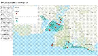
The Department of Environmental Protection (DEP) has announced the launch of an online mapping tool aimed at enhancing the resilience of New Jersey’s coastal areas to climate change. The Coastal Ecological Restoration and Adaptation Planning Tool (CERAP Tool) provides valuable data and information to assist in the targeting, development, and coordination of projects needed to adapt communities to the impacts of climate change. Developed in partnership with Rutgers University’s Center for Remote Sensing and Spatial Analysis, the tool will support the achievement of the Sustainable Development Goals (SDGs) by addressing climate impacts and promoting community resilience.
Targeting and Coordinating Coastal Resilience Projects
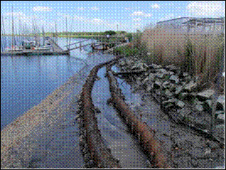
The CERAP Tool provides the locations of at-risk areas, coastal resource restoration sites, and other relevant data to inform targeted investments in restoration and resilience projects. By addressing issues such as rising sea levels, increased flooding, and severe storms associated with climate change, the tool supports the implementation of storm and flood-protection projects, resource restoration, and nature-based solutions. Furthermore, the data obtained from the tool can be used to support applications for federal and state funding opportunities.
Supporting New Jersey’s Climate Change Resilience Strategy
The mapping tool aligns with New Jersey’s Climate Change Resilience Strategy by equipping coastal municipal planners and non-profit partners with a resource to coordinate coastal restoration projects. This coordination aims to enhance community resilience, promote ecosystem health, and maximize carbon sequestration. The tool also addresses eight primary stressors identified through consultation with regional stakeholders and experts in New Jersey’s coastal ecosystem, including coastal ecosystem degradation, shoreline erosion, coastal flood damage, and water quality degradation.
Enhancing Coastal Environment Management
The CERAP Tool offers additional layers of information, including past, current, or proposed coastal resilience projects, as well as areas of local and regional concern. By combining these datasets with existing data on vulnerabilities, natural resources, societal factors, and ownership, the tool provides a holistic view of the state’s coastal environment. This comprehensive understanding enables the evaluation of intervention strategies, the identification of restoration sites, and the assessment of project vulnerability.
Informing Future Projects and Actions
The mapping tool serves as a catalogue of sites and projects, informing the DEP and other stakeholders about resource allocation for future projects. It utilizes a bottom-up approach by harnessing local knowledge to identify problem areas and recognize gaps in coastal zone management. Additionally, the tool can be used to assess areas for restoration, evaluate proposed acquisition sites, determine project vulnerability, and leverage past restoration efforts for new actions.
Building on Prior Recommendations
The development of the mapping tool was funded through a U.S. Environmental Protection Agency Region 2 Wetlands Programmatic Grant. It incorporates the goals and objectives of prior recommendations from New Jersey’s Climate Change Resilience Strategy, DEP’s Blue Acres acquisition program, and Rebuild by Design efforts. By applying these recommendations to vulnerable coastal areas, the tool contributes to the achievement of the SDGs.
For more information on the Coastal Ecological Restoration and Adaptation Planning Tool, visit nj.gov/dep/climatechange/njcerap.html.
SDGs, Targets, and Indicators
-
SDG 13: Climate Action
- Target 13.1: Strengthen resilience and adaptive capacity to climate-related hazards and natural disasters in all countries
- Target 13.2: Integrate climate change measures into national policies, strategies, and planning
- Indicator 13.1.1: Number of deaths, missing persons, and directly affected persons attributed to disasters per 100,000 population
- Indicator 13.2.1: Number of countries that have integrated mitigation, adaptation, impact reduction, and early warning into their national policies, strategies, and planning
-
SDG 15: Life on Land
- Target 15.1: By 2020, ensure the conservation, restoration, and sustainable use of terrestrial and inland freshwater ecosystems and their services
- Target 15.2: By 2020, promote the implementation of sustainable management of all types of forests, halt deforestation, restore degraded forests, and substantially increase afforestation and reforestation globally
- Indicator 15.1.1: Forest area as a proportion of total land area
- Indicator 15.2.1: Progress towards sustainable forest management
Analysis
The article discusses the launch of an online mapping tool that aims to bolster the resilience of New Jersey’s coastal areas to climate change. Based on the content of the article, the following SDGs, targets, and indicators can be identified:
1. SDG 13: Climate Action
The mapping tool is directly connected to SDG 13 as it aims to address climate change impacts on New Jersey’s coastal communities. It helps in the development of storm and flood-protection projects, resource restoration, and nature-based solutions to mitigate climate change impacts.
Targets:
- Target 13.1: Strengthen resilience and adaptive capacity to climate-related hazards and natural disasters in all countries
- Target 13.2: Integrate climate change measures into national policies, strategies, and planning
Indicators:
- Indicator 13.1.1: Number of deaths, missing persons, and directly affected persons attributed to disasters per 100,000 population
- Indicator 13.2.1: Number of countries that have integrated mitigation, adaptation, impact reduction, and early warning into their national policies, strategies, and planning
2. SDG 15: Life on Land
The mapping tool also relates to SDG 15 as it supports the conservation, restoration, and sustainable use of terrestrial and inland freshwater ecosystems. It helps in identifying areas for restoration, evaluating habitat vulnerability, and leveraging past restoration efforts with new actions.
Targets:
- Target 15.1: By 2020, ensure the conservation, restoration, and sustainable use of terrestrial and inland freshwater ecosystems and their services
- Target 15.2: By 2020, promote the implementation of sustainable management of all types of forests, halt deforestation, restore degraded forests, and substantially increase afforestation and reforestation globally
Indicators:
- Indicator 15.1.1: Forest area as a proportion of total land area
- Indicator 15.2.1: Progress towards sustainable forest management
Table: SDGs, Targets, and Indicators
| SDGs | Targets | Indicators |
|---|---|---|
| SDG 13: Climate Action |
|
|
| SDG 15: Life on Land |
|
|
Behold! This splendid article springs forth from the wellspring of knowledge, shaped by a wondrous proprietary AI technology that delved into a vast ocean of data, illuminating the path towards the Sustainable Development Goals. Remember that all rights are reserved by SDG Investors LLC, empowering us to champion progress together.
Source: nj.gov
![]()
Join us, as fellow seekers of change, on a transformative journey at https://sdgtalks.ai/welcome, where you can become a member and actively contribute to shaping a brighter future.


