


The Nagorno-Karabakh Conflict: a visual explainer
In 1988, ethnic Armenians living in Nagorno-Karabakh demanded their independence from the Soviet Union state of Azerbaijan and transfer of governance to Armenia. After the collapse of the Soviet Union, fighting continued in the region as Azerbaijan citizens fled Armenia and Armenians fled Azerbaijan. In April of 2016, four days of conflict at the desperation line killed hundreds on both sides. In 2020, complete war resumed and six weeks of armed fighting ensured before a peace was brokered by the Russian government. Currently, although a cease fire has been initiated, the border between the countries stands similarly to the DMZ in North/South Korea. At least 1,225 people have been killed in the conflict with at least 53 of those being non-combatents. Modern methods of warfare were used in this conflict such as drone strikes and heavy weaponry. Mines deployed during this conflict are the predominant source of non-combatent injuries and deaths.

The Nagorno-Karabakh conflict is the longest-running in post-Soviet Eurasia. In 1988, ethnic Armenians living in Nagorno-Karabakh demanded the transfer of what was then the Nagorno-Karabakh Autonomous Oblast (NKAO) from Soviet Azerbaijan to Armenia. As the Soviet Union collapsed, tensions grew into an outright war. When fighting ceased in 1994, Nagorno-Karabakh and seven adjacent districts were wholly or partially controlled by Armenian forces. More than a million people had been forced from their homes: Azerbaijanis fled Armenia, Nagorno-Karabakh and the adjacent territories, while Armenians left homes in Azerbaijan.
From 1994 until 2020, intermittent deadly incidents, including the use of attack drones and heavy weaponry on the front lines and activities of special operations forces, demonstrated the ever-present risk that war would reignite. In April 2016, four days of intense fighting at the line of separation shook the region, killed hundreds on both sides, and foreshadowed what was to come.
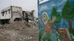
The dam broke in September 2020, and full-fledged war resumed on the 27th of that month. Six weeks of bloody armed conflict finally ended in the early hours of 10 November with a ceasefire brokered by the Russian Federation. Although the deal fell short of a clear and stable peace, it brought an end to the deadliest fighting the region had witnessed in nearly three decades with over 7,000 military and about 170 civilians killed and many more wounded. Under the agreement, Azerbaijan now again controls in full the seven districts adjacent to Nagorno-Karabakh that Armenian forces had held since the previous war. It also holds a substantial part of Nagorno-Karabakh itself. The rest is patrolled by a Russian peacekeeping force but still governed by self-proclaimed local authorities.
This Visual Explainer has been designed as a resource for those seeking to understand this conflict. It is also intended as a tool for policymakers and others involved in the peace process or in mitigating the conflict’s humanitarian impact. It includes sections that explain the current state of the conflict along with some parts that describe the situation before the 2020 war:
-
Regularly updated maps and graphs depicting the evolving situation since the end of hostilities in November 2020.
-
A timeline tracking critical political events from the beginning of 2015 to the present.
-
Historical graphics that track incidents and casualties between January 2015 and the day before the start of the second war on 27 September 2020. This section includes a brief discussion of the April 2016 escalation, which is not, however, included in the data tracking.
-
A methodology and terminology section that includes datasets used to generate the timeline, graphs and interactive maps.
After the 2020 war, the front line has become longer and more volatile than before. Opposing military positions are separated from one another by only 30-100 metres. Before the 2020 war, they were hundreds of metres apart. The front line’s movement has placed military positions up against civilian settlements. The Russian peacekeeping mission’s outposts are deployed along the main roads in Armenian-populated areas of the conflict zone and the main traffic artery between Armenia and Nagorno-Karabakh, including inside the Lachin corridor. The joint Russian-Turkish monitoring centre established as part of the November 2020 agreement, sits in Azerbaijani territory about 20km from the front line.
Click on source for opening the interactive maps.
What is Your Reaction?
 Like
1
Like
1
 Dislike
0
Dislike
0
 Love
0
Love
0
 Funny
0
Funny
0
 Angry
0
Angry
0
 Sad
0
Sad
0
 Wow
0
Wow
0