


Aquifer study moves forward in upper John Day River Valley – Elkhorn Media Group
Report on the Upper John Day River Aquifer Management Feasibility Study
1.0 Introduction and Executive Summary
A feasibility study has been conducted in the John Day River Valley to assess groundwater resources for potential aquifer storage and recovery (ASR) projects. This initiative, led by the Grant Soil and Water Conservation District (GSWCD) in partnership with the Bureau of Reclamation (BOR) and the Oregon Department of Emergency Management (OEM), directly addresses critical water management challenges. The project’s objectives and outcomes are strongly aligned with several United Nations Sustainable Development Goals (SDGs), particularly those concerning water security, climate action, and sustainable communities.
2.0 Project Objectives and Contribution to SDG 6 (Clean Water and Sanitation)
The primary goal of the study is to enhance local water security by exploring innovative water storage solutions in a region with limited capacity for surface reservoirs. This directly supports SDG 6, which aims to ensure the availability and sustainable management of water for all.
- Objective 1: To map and quantify underground water resources in the John Day River Valley.
- Objective 2: To identify suitable geological formations for ASR systems, where water can be stored during wet seasons and extracted during dry periods for irrigation and community use.
- SDG Alignment: The project promotes integrated water resources management (Target 6.5) and aims to increase water-use efficiency and ensure sustainable withdrawals to combat water scarcity (Target 6.4).
3.0 Methodology and Technological Application
The study employed advanced geophysical survey techniques to create a detailed model of the subsurface geology. This science-based approach is fundamental to developing effective and sustainable water management solutions.
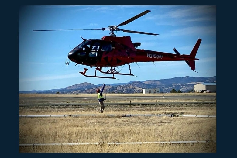
- Airborne Electromagnetic (AEM) Survey: A helicopter equipped with a sensor array transmitted an electromagnetic field into the ground. By measuring the ground’s response (inductive coupling), scientists could determine key characteristics such as bedrock depth and the structure of underground layers.
- Light Detection and Ranging (LIDAR): This technology used laser pulses from an aircraft to generate a highly accurate topographical map of the land’s surface.
- Data Integration: The combined results from AEM and LIDAR surveys will guide the selection of locations for drilling and testing exploratory wells to confirm their suitability for ASR.
4.0 Broader Implications for Sustainable Development Goals
Beyond its primary focus on water management, this initiative contributes to a wider range of SDGs, demonstrating a holistic approach to regional sustainability and resilience.
- SDG 2 (Zero Hunger): By securing water for irrigation during dry months, the project supports sustainable agricultural practices and enhances food security for the local community (Target 2.4).
- SDG 11 (Sustainable Cities and Communities): The initiative strengthens the community’s resilience to water-related disasters like drought, making it a more sustainable and secure place to live (Target 11.5).
- SDG 13 (Climate Action): The project is a direct climate adaptation strategy, building resilience and adaptive capacity to the impacts of changing weather patterns and increased drought frequency (Target 13.1).
- SDG 17 (Partnerships for the Goals): The collaboration between local (GSWCD), state (OEM), and federal (BOR, FEMA) entities exemplifies the multi-stakeholder partnerships essential for achieving sustainable development (Target 17.16).
5.0 Conclusion and Forward Outlook
The findings from the airborne survey represent a significant advancement in understanding the John Day Valley’s hydrogeology. The project serves as a model for how local communities can leverage technology and inter-agency partnerships to implement science-based solutions for climate adaptation. By proactively managing water resources, the GSWCD and its partners are taking crucial steps to secure a sustainable future for the region, in full alignment with the principles of the UN Sustainable Development Goals.
1. Which SDGs are addressed or connected to the issues highlighted in the article?
Identified SDGs
- SDG 6: Clean Water and Sanitation: The core of the article focuses on managing water resources, specifically addressing water scarcity through the study of groundwater and aquifer storage. The project’s goal is to ensure a stable water supply for irrigation and community use, which is central to SDG 6.
- SDG 2: Zero Hunger: The article explicitly states that a key purpose of the potential water storage is for “irrigation.” By securing water for agriculture, especially during dry seasons, the project directly supports sustainable food production and resilient agricultural practices, which is a key aspect of SDG 2.
- SDG 11: Sustainable Cities and Communities: The project aims to protect water supplies for “farms and communities,” thereby enhancing the resilience of the local community to water-related disasters like drought. The article mentions that this is a “mitigation grant” project, aligning with the goal of making communities safer and more resilient.
- SDG 13: Climate Action: The article frames the project as a response to “drought and other climate challenges” and changing weather patterns. It is presented as a “science-based solution” to help communities adapt to the impacts of climate change, which directly relates to SDG 13’s call for strengthening resilience and adaptive capacity.
2. What specific targets under those SDGs can be identified based on the article’s content?
Identified Targets
- Under SDG 6 (Clean Water and Sanitation):
- Target 6.4: By 2030, substantially increase water-use efficiency across all sectors and ensure sustainable withdrawals and supply of freshwater to address water scarcity. The project’s aim to store water during wet seasons for use in dry months is a direct strategy to ensure a sustainable supply of freshwater and address seasonal water scarcity for the community and agriculture.
- Target 6.5: By 2030, implement integrated water resources management at all levels. The “Upper John Day River Aquifer Management Feasibility Study” is a practical example of integrated water resources management at the local level, combining geological surveys, technology, and community planning to manage groundwater.
- Target 6.b: Support and strengthen the participation of local communities in improving water and sanitation management. The project is led by the local “Grant Soil and Water Conservation District (GSWCD)” and involves public presentations, demonstrating the active role of the local community in managing their water resources.
- Under SDG 2 (Zero Hunger):
- Target 2.4: By 2030, ensure sustainable food production systems and implement resilient agricultural practices that… strengthen capacity for adaptation to climate change, extreme weather, drought… The aquifer storage project is a resilient agricultural practice designed to help local farming adapt to drought, ensuring water is available for irrigation and thereby supporting sustainable food production.
- Under SDG 11 (Sustainable Cities and Communities):
- Target 11.5: By 2030, significantly reduce… the number of people affected… by disasters, including water-related disasters… Drought is a significant water-related disaster. The project is a mitigation effort, funded by FEMA and OEM, to reduce the community’s vulnerability and the potential impact of future droughts.
- Under SDG 13 (Climate Action):
- Target 13.1: Strengthen resilience and adaptive capacity to climate-related hazards and natural disasters in all countries. The article explicitly states the project helps communities “prepare for drought and other climate challenges.” This initiative is a direct action to build local resilience and adaptive capacity to the impacts of climate change.
3. Are there any indicators mentioned or implied in the article that can be used to measure progress towards the identified targets?
Implied Indicators
The article does not mention official SDG indicators, but it implies several metrics that could be used to measure progress:
- Volume of potential water storage: The study’s primary goal is to determine “how much underground water we have, and how much could be stored.” This volume would be a direct indicator of progress towards increasing freshwater supply (Target 6.4).
- Implementation of a water management plan: The existence and execution of the “Upper John Day River Aquifer Management Feasibility Study” itself serves as an indicator for implementing integrated water resources management (Target 6.5).
- Number of aquifer storage and recovery wells installed: The article states the survey’s goal is to “find places where underground water storage wells could be built.” The successful identification of sites and subsequent construction of wells would be a tangible indicator of progress.
- Area of irrigated land secured during drought: The stated use for the water is “irrigation.” An indicator of success for Target 2.4 would be the ability to maintain or expand irrigated agriculture during dry periods using the stored water.
- Adoption of science-based climate adaptation solutions: The article suggests the project could be a “good example of how small communities can use technology to manage water wisely.” The successful implementation of this project serves as an indicator of a community strengthening its resilience and adaptive capacity to climate change (Target 13.1).
4. Create a table with three columns titled ‘SDGs, Targets and Indicators’ to present the findings from analyzing the article.
| SDGs | Targets | Indicators (Implied from the article) |
|---|---|---|
| SDG 6: Clean Water and Sanitation | 6.4: Ensure sustainable withdrawals and supply of freshwater to address water scarcity.
6.5: Implement integrated water resources management. 6.b: Support and strengthen the participation of local communities. |
– Volume of water that can be stored and recovered through the aquifer system.
– Successful completion and implementation of the Aquifer Management Feasibility Study. – Active project leadership by the local Grant Soil and Water Conservation District. |
| SDG 2: Zero Hunger | 2.4: Implement resilient agricultural practices and adapt to climate change and drought. | – Acreage of farmland with secured water supply for irrigation during dry seasons. |
| SDG 11: Sustainable Cities and Communities | 11.5: Reduce the number of people affected by water-related disasters (drought). | – Development and funding of a local drought mitigation project (the ASR system). |
| SDG 13: Climate Action | 13.1: Strengthen resilience and adaptive capacity to climate-related hazards. | – Implementation of a science-based solution (ASR) to adapt to climate challenges like drought. |
Source: elkhornmediagroup.com
What is Your Reaction?
 Like
0
Like
0
 Dislike
0
Dislike
0
 Love
0
Love
0
 Funny
0
Funny
0
 Angry
0
Angry
0
 Sad
0
Sad
0
 Wow
0
Wow
0